

Leader mondiali, responsabili politici e delegati di quasi 200 paesi si sono riuniti nelle ultime due settimane a Sharm El-Sheikh in occasione del vertice sul clima delle Nazioni Unite “COP27”. Oggi diamo un'occhiata più da vicino a questa città egiziana utilizzando gli occhi di Copernicus Sentinel-2.
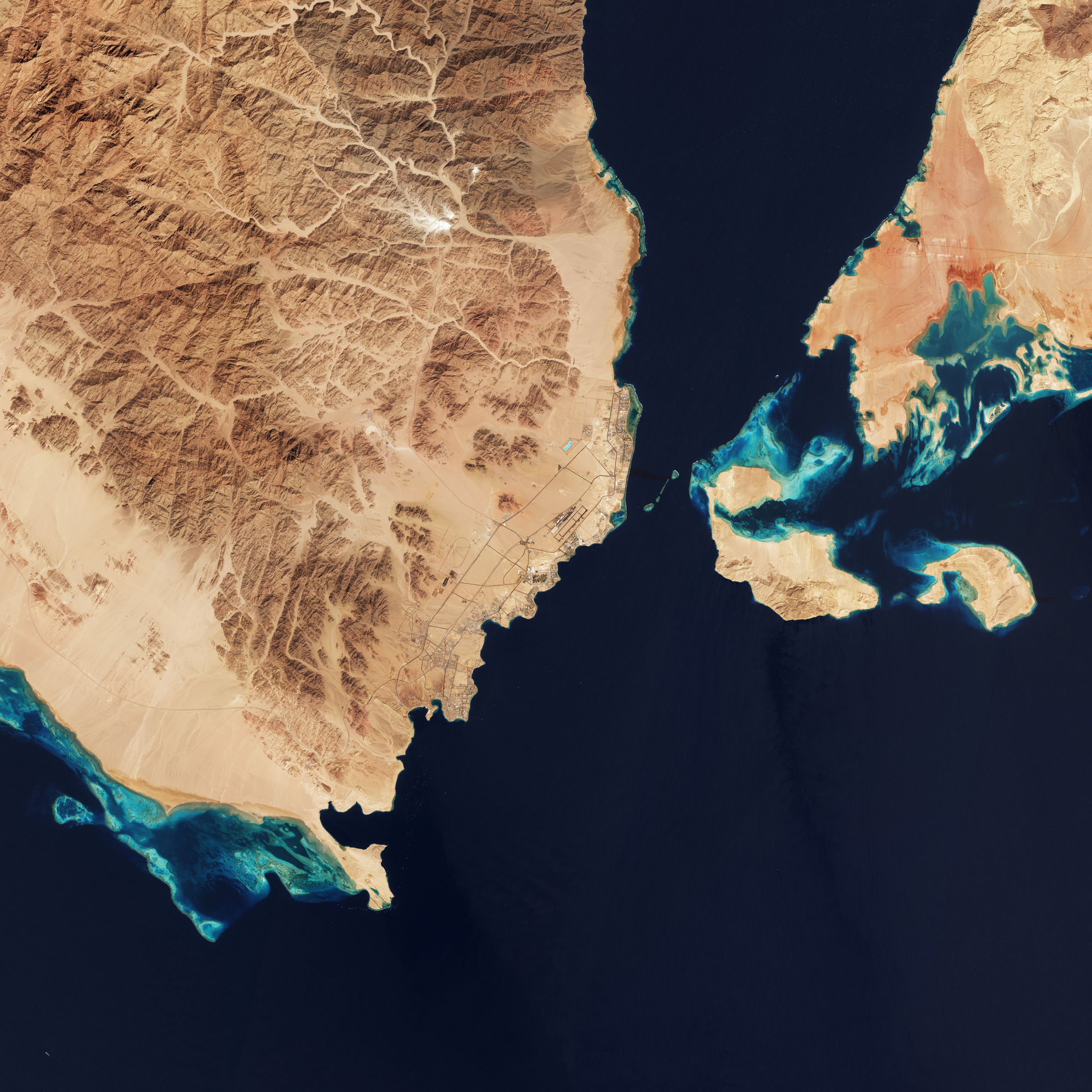
Sharm El-Sheikh è una città turistica egiziana sulla punta sud-est della penisola del Sinai, sulla fascia costiera lungo il Mar Rosso. La costa è costellata di ristoranti, bar e resort. Questa sorprendente immagine a colori reali mostra in alto a destra il Golfo di Aqaba che alimenta il Mar Rosso, che è sede di alcune delle acque marine più calde e salate del mondo.
Il Mar Rosso è collegato al Mar Mediterraneo tramite il Canale di Suez (non visibile), uno dei corsi d'acqua più trafficati del mondo.
L'area offre molte opportunità per le immersioni. Una serie di barriere coralline, che ospitano una ricca vita marina, può essere facilmente individuata osservando l'immagine. Le variazioni nel colore dell'acqua che circonda le isole e nella destra dell'immagine sono indice della la profondità dell'acqua: le aree più chiare mostrano acque più basse rispetto alla vasta distesa di colore blu intenso / turchese.
Nelle ultime due settimane i leader mondiali stanno discutendo le azioni per affrontare i cambiamenti climatici al Vertice sul Clima COP27. Con il pianeta sulla strada del raggiungimento di un riscaldamento di 2,4-2,6 gradi C (rispetto ai livelli preindustriali) e di fronte agli avvertimenti di future catastrofi da parte delle Nazioni Unite, l'obiettivo centrale della conferenza è stato quello di limitare le future emissioni di gas serra e affrontare le perdite e i danni derivanti dalle inevitabili conseguenze dei cambiamenti climatici.
In qualità di osservatore ufficiale alla COP27, i rappresentanti dell'ESA hanno partecipato a tutto l'evento per evidenziare il valore delle osservazioni spaziali, non solo per la comprensione scientifica del clima e per come migliorare le previsioni dei cambiamenti futuri, ma anche per dimostrare come i dati delle missioni spaziali possano supportare gli impegni presi alla COP.
L'ESA ha anche dimostrato come il crescente uso dei dati satellitari stia consentendo alla comunità globale di intraprendere azioni per il clima e monitorare i progressi negli impegni assunti a livello nazionale per limitare il riscaldamento globale e sanciti dall'accordo di Parigi.
Il satellite Copernicus Sentinel-5P si è rivelato cruciale nell'attuazione dell'ambizioso progetto Methane Alert and Response System (MARS). L’iniziativa mira ad aumentare gli sforzi globali per rilevare e agire sulle principali fonti di emissioni e accelerare l'attuazione del Global Methane Pledge.
Attraverso il suo progetto REgional Carbon Cycle Assessment and Processes (RECCAP-2), la Climate Change Initiative dell'ESA è pioniere nella ricerca su come utilizzare i dati spaziali per migliorare le stime dei flussi superficiali tra atmosfera, terra e oceano da confrontare con le stime su scala nazionale.
Scopri di più su come lo spazio può rispondere alle minacce causate dalla crisi climatica esplorando il kit interattivo Climate Change from Space dell'ESA.
Scarica immagine MedRes (16,45 MB - .JPG)
Scarica immagine HighRes (109,01 MB - .TIF)
---
Sharm El-Sheikh, Egypt
World leaders, policymakers and delegates from nearly 200 countries have convened in Sharm El-Sheikh over the past two weeks at the COP27 UN Climate Summit. Today we take a closer look at the Egyptian city through the eyes of Copernicus Sentinel-2.
Sharm El-Sheikh is an Egyptian resort city on the southeast tip of the Sinai Peninsula, on the coastal strip along the Red Sea. The coastline is dotted with restaurants, bars and resorts. This striking true-colour image shows the Gulf of Aqaba at the top-right, feeding into the Red Sea – home to some of the hottest and saltiest seawater in the world.
The Red Sea is connected to the Mediterranean Sea via the Suez Canal (not visible), one of the world’s busiest waterways.
The area offers many opportunities for diving. A series of coral reefs, which host rich marine life, can be easily spotted in the image. The variations in the colour of the water surrounding the islands and in the right of the image represent the depth of water. The lighter areas show more shallow waters than the vast expanse of deep blue/turquoise.
Over the past two weeks, world leaders are discussing action to tackle climate change at the COP27 Climate Summit. With the planet on course for 2.4-2.6 degree C warming (relative to pre-industrial levels) and warnings of future catastrophe from the UN, the conference’s central focus has been on limiting future greenhouse emissions and addressing loss and damage resulting from the unavoidable consequences of climate change.
As an official observer to COP27, ESA representatives have been participating throughout the event to highlight the value of space-based observations, not only for the scientific understanding of climate and how to improve predictions of future change, but also proving how space data can support commitments made at COP.
ESA has also shown how the growing use of satellite data is enabling the global community to take climate action and track progress towards nationally pledged commitments to limit global warming that are enshrined in the Paris Agreement.
The Copernicus Sentinel-5P satellite has proved crucial in implementing the ambitious Methane Alert and Response System (MARS) initiative. The project aims to scale up global efforts to detect and act on major emissions sources and accelerate the implementation of the Global Methane Pledge.
Through its REgional Carbon Cycle Assessment and Processes project (RECCAP-2), ESA’s Climate Change Initiative is pioneering research in how to use space data to improve estimates of surface fluxes between the atmosphere, land and ocean to compare to national-scale estimates.
Find out more about how space can respond to the threats posed by the climate crisis by exploring ESA’s interactive Climate Change from Space kit.
[Credits: contains modified Copernicus Sentinel data (2022), processed by ESA - Translation: Gianluca Pititto]
Copia qui lo "short link" a questo articolo
www.geoforall.it/{sh404sef_shurl}
