

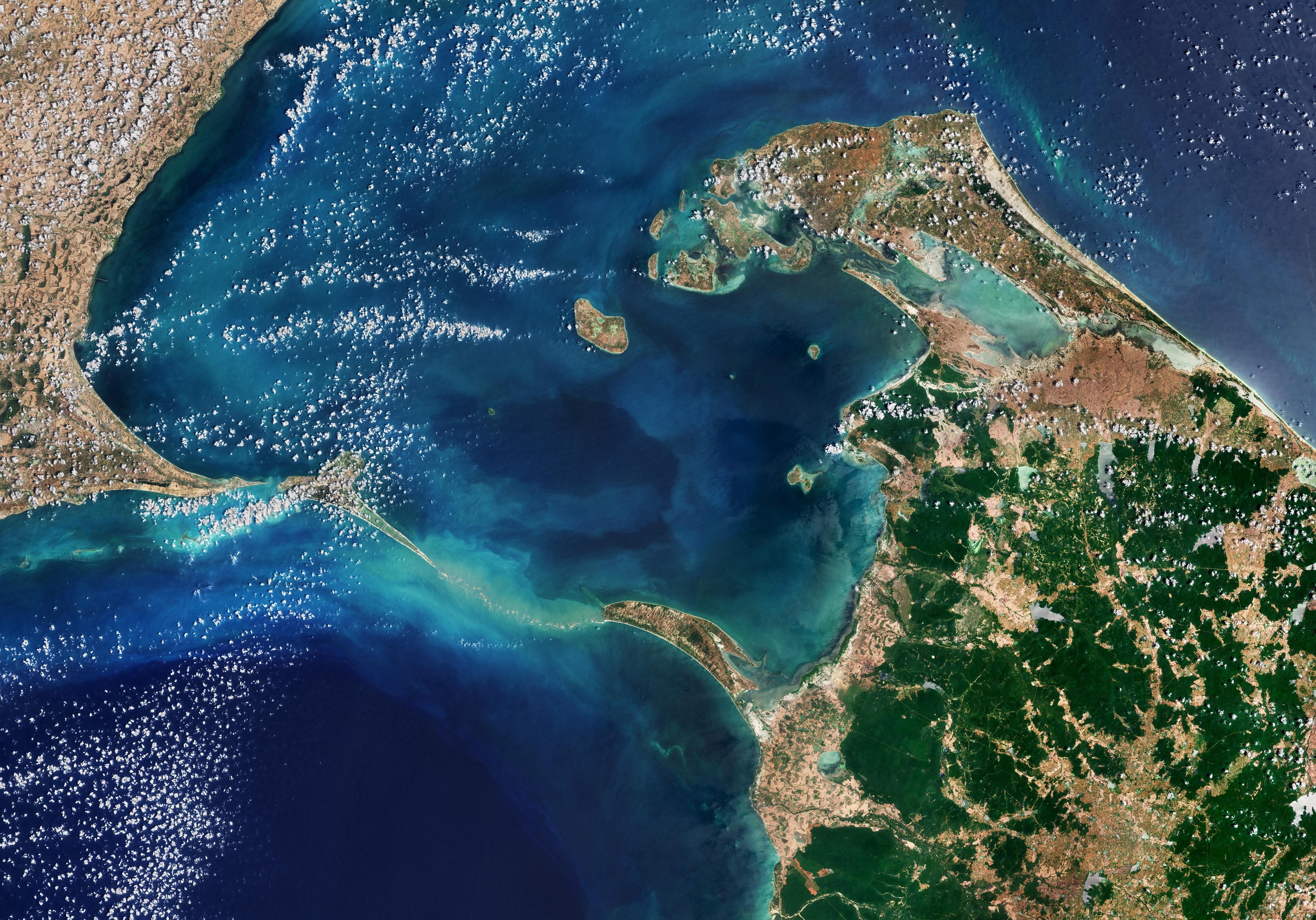
Questa immagine di Copernicus Sentinel-2 mostra il Ponte di Adamo, una catena di secche che collegano l'India e lo Sri Lanka.
Il ponte di Adamo si estende per 48 km tra l'isola di Rameswaram, al largo della costa sud-orientale dell'India, e l'isola di Mannar, al largo della costa nord-occidentale dello Sri Lanka. Il ponte separa il Golfo di Mannar (a sud, un'insenatura dell'Oceano Indiano) dallo stretto di Palk (a nord, un'insenatura del Golfo del Bengala).
Ci sono numerose teorie su come si sia formato il ponte. Tuttavia, le prove geologiche suggeriscono che questi banchi di calcare siano i resti della terra che un tempo collegava l'India e lo Sri Lanka. Secondo documentazione storica, questo ponte naturale è stato attraversabile fino al XV secolo, dopodichè nel corso degli anni è stato gradualmente eroso dalle tempeste.
Alcuni banchi di sabbia sono asciutti e, come indica il colore chiaro dell'acqua, il mare qui è molto basso, profondo solo 1-10 m.
L'isola di Mannar presenta una superficie di circa 130 kmq ed è collegata allo Sri Lanka continentale da un ponte stradale e da un ponte ferroviario, entrambe visibili all'estremità meridionale dell'isola.
Sul lato opposto del ponte di Adamo si trova l'isola di Rameswaram, nota anche come isola di Pamban, che è accessibile dalla terraferma indiana attraverso il ponte Pamban lungo 2 km. Le due città principali dell'isola sono Pamban (sul bordo occidentale) e Rameswaram (a circa 10 km ad est di Pamban).
Entrambe le sezioni del ponte di Adamo fanno parte di parchi nazionali protetti all’interno dei rispettivi paesi. Le dune di sabbia fungono da terreno di riproduzione per uccelli come il noddy marrone, mentre nelle acque poco profonde prosperano numerose specie di pesci e alghe. La vita marina intorno al Ponte di Adamo include delfini, dugonghi e tartarughe.
Scarica immagine HiRes (4,96 MB - .JPG)
Scarica immagine HiRes (544,77 MB - .TIFF)
---
Ponte di Adamo
This Copernicus Sentinel-2 image shows Adam’s Bridge, a chain of shoals linking India and Sri Lanka.
Adam’s Bridge stretches 48 km between Rameswaram Island, off the southeast coast of India, and Mannar Island, off the northwest coast of Sri Lanka. The bridge separates the Gulf of Mannar (south), an inlet of the Indian Ocean, from the Palk Strait (north), an inlet of the Bay of Bengal.
There are numerous theories about how the bridge was formed. However, geologic evidence suggests that these limestone shoals are the remnants of land that once connected India and Sri Lanka. According to records, this natural bridge was traversable until the15th century, after which it was gradually eroded by storms over the years.
Some of the sandbanks are dry and, as the light colour of the water indicates, the sea here is very shallow, only 1–10 m deep.
Mannar Island covers about 130 sq km and is connected to mainland Sri Lanka by a road bridge and a railway bridge, both visible at the southern end of the island.
On the opposite side of Adam’s bridge, Rameswaram Island, also known as Pamban Island, can be accessed from the Indian mainland by the 2-km-long Pamban Bridge. The two main towns on the island are Pamban, on the western edge, and Rameswaram, around 10 km east of Pamban.
Both sections of Adam’s Bridge are part of protected national parks in their respective countries. The sand dunes serve as breeding grounds for birds such as the brown noddy, while numerous species of fish and sea grasses thrive in the shallow waters. Sea life around Adam's Bridge include dolphins, dugongs and turtles.
[Credits: contains modified Copernicus Sentinel data (2024), processed by ESA - Translation: Gianluca Pititto]
