

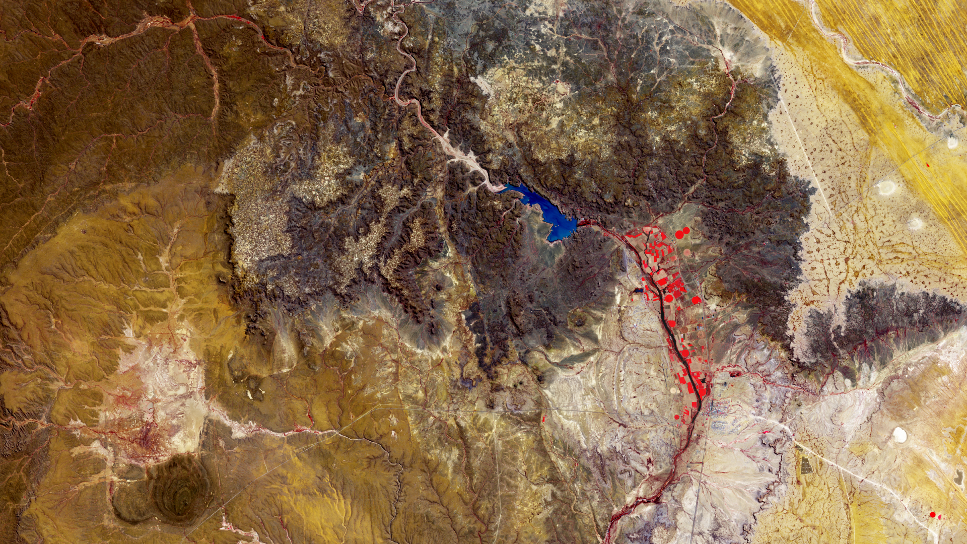
Simile ad una superficie che ricorda quella marziana, questa immagine di Copernicus Sentinel-2 mostra parte della regione di Hardap nella Namibia centro-meridionale, sul confine occidentale del deserto del Kalahari.
Hardap è una regione calda ed arida, dove le acque sotterranee sono difficili da estrarre. Il suo nome riflette l'importanza della diga di Hardap, la seconda diga più grande della Namibia, visibile in blu al centro dell'immagine. Le varie tonalità blu denotano la presenza di sedimenti nell'acqua.
Con una superficie di 25 kmq la diga fornisce elettricità ed acqua a tutta l'area ed il bacino idrico ospita numerose specie della fauna selvatica della Namibia.
La diga controlla il flusso del fiume Fish, che si può osservare nel suo serpeggiare attraverso l'immagine. In questa acquisizione in falsi colori, catturata il 28 agosto 2024, il canale del vicino infrarosso di Copernicus Sentinel-2 è stato utilizzato per evidenziare in rosso la vegetazione, la quale appare concentrata lungo il fiume principalmente a sud della diga.
I terreni agricoli possono essere riconosciuti nella pianura alluvionale sotto la diga, dove principalmente vengono coltivati ortaggi e agrumi. Le diverse tonalità di rosso mostrano lo stato delle colture: più il rosso è acceso, più sana risulta la vegetazione.
A circa 20 km a sud-est della diga, sulla riva orientale del fiume, si trova la città di Mariental, il capoluogo della regione. Il suo ambiente urbano è osservabile come un miscuglio di punti rossi e grigi. Vicino a Mariental la pianura rocciosa dell'Altopiano Centrale si fonde con il terreno secco e sabbioso dei confini occidentali del deserto del Kalahari.
L'intero Kalahari occidentale è caratterizzato da lunghe catene di dune di sabbia. Alcune di queste dune appaiono con toni di giallo nell'angolo in alto a destra e si mostrano sorprendentemente parallele ed uniformi.
Sul lato destro dell'immagine il paesaggio è punteggiato da letti di laghi asciutti noti come saline, visibili come cerchi bianchi scintillanti. Le strade possono essere individuate come linee bianche che tagliano bruscamente il paesaggio.
Scarica immagine HiRes (1,03 MB - .JPG)
Scarica immagine HiRes (18,35 MB - .TIF)
---
Hardap Dam, Namibia
Resembling a Martian-like surface, this Copernicus Sentinel-2 image shows part of the Hardap region in south-central Namibia on the western edge of the Kalahari Desert.
Hardap is a hot and arid region, where groundwater is difficult to obtain. Its name reflects the importance of the Hardap Dam, Namibia’s second largest dam, visible in blue in the centre of the image. The various blue hues denote the presence of sediment in the water.
With a surface area of 25 sq km, the dam supplies electricity and water to the whole area and the reservoir is home to numerous examples of Namibia’s wildlife.
The dam controls the flow of the Fish River, which can be seen snaking its way across the image. In this false-colour image, captured on 28 August 2024, the Copernicus Sentinel-2’s near-infrared channel was used to highlight vegetation in red, which appears mainly concentrated south of the dam along the river.
Agricultural fields can be spotted on the floodplain below the dam, where mainly vegetables and citrus fruits are grown. The different shades of red show the state of the crops: the brighter the red, the healthier is the vegetation.
About 20 km southeast of the dam, on the eastern bank of the river, lies the town of Mariental, the region’s capital. Its urban environment can be seen as a blend of red and grey dots. Near Mariental, the rocky plain of the Central Highland merges with the dry, sandy soil of the western limits of the Kalahari Desert.
The entire western Kalahari is characterised by long chains of sand dunes. Some of these dunes can be seen in shades of yellow in the top-right corner and appear surprisingly parallel and uniform.
On the right side of the image, the landscape is dotted with dry lake beds known as salt pans, seen as gleaming white circles. Roads can be identified as white lines cutting sharply across the landscape.
[Credits: contains modified Copernicus Sentinel data (2024), processed by ESA - Translation: Gianluca Pititto]
