

La missione Copernicus Sentinel-2 ci porta sopra la città di Tashkent, la capitale dell'Uzbekistan.
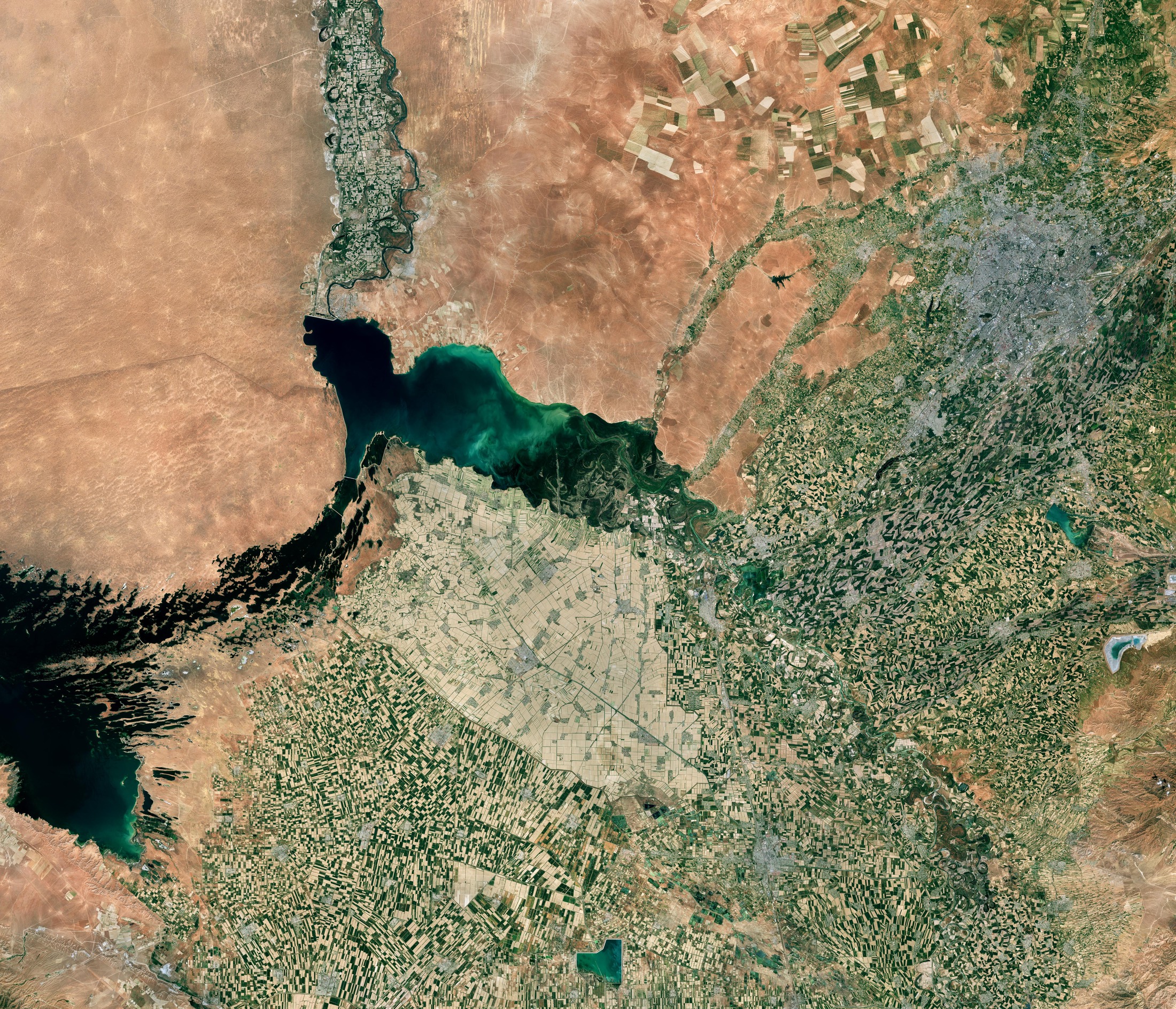
Visibile come un’area grigia in alto a destra dell'immagine, Tashkent è la città più grande dell'Asia centrale. E' situata nel nord-est dell'Uzbekistan, nelle vicinanze del confine con il Kazakistan. La città sorge nella valle del fiume Chirchiq.
L’immagine è dominata da vasti campi agricoli, in particolare nella parte inferiore. Il cotone è la coltura principale in questa regione, ma vengono coltivati anche grano, riso, iuta, meloni e verdure.
Lo specchio d'acqua di colore verde scuro al centro dell'immagine è il bacino di Shardara, un lago artificiale situato interamente all'interno del Kazakistan. Lungo i confini della macchia più chiara di terreno coltivato, visibile a sud del bacino, corre il confine tra Kazakistan e Uzbekistan.
I colori più chiari all’interno del bacino indicano la presenza di sedimenti. La riserva, che viene utilizzata per l'irrigazione, si deve alla realizzazione della diga di Chardara, visibile sulla riva nord-occidentale. È alimentata dal fiume Syr Darya, che entra nel bacino da sud-est e scorre a nord-ovest, lungo la striscia verde di campi agricoli nella parte superiore dell'immagine, all'interno del deserto circostante.
A ovest del fiume si trova il deserto di Kyzylkum, il 15° deserto più grande del mondo. Il lago Aydar si trova immediatamente a sud. Fa parte del sistema artificiale di laghi Aydar-Arnasay, che - coprendo un totale area di 4000 kmq - costituisce il più grande bacino idrico in Uzbekistan.
Copernicus Sentinel-2 è progettato per fornire immagini che possono essere utilizzate per distinguere tra diversi tipi di colture e per monitorare accuratamente la crescita delle piante. Le frequenti rivisitazioni della missione della stessa area e l'elevata risoluzione spaziale consentono inoltre di monitorare attentamente i cambiamenti nei corpi idrici interni.
Scarica immagine MedRes (6,05 MB - .JPG)
Scarica immagine HighRes (825,16 MB - .TIF)
---
Tashkent, Uzbekistan
The Copernicus Sentinel-2 mission takes us over Tashkent, the capital city of Uzbekistan.
Visible as the grey area in the top right of the image, Tashkent is the largest city in Central Asia. It lies in northeast Uzbekistan, near the border with Kazakhstan. The city is situated in the Chirchiq River valley.
Vast agricultural fields dominate the image, particularly at the bottom. Cotton is the chief crop in this region, but wheat, rice, jute, melons and vegetables are also grown.
The dark green body of water in the centre of the image is the Shardara Reservoir, an artificial lake located entirely within Kazakhstan. Along the edges of the lighter patch of cultivated land, visible south of the reservoir, runs the border between Kazakhstan and Uzbekistan.
The lighter colours in the reservoir indicate the presence of sediment. The reservoir, which is used for irrigation, is the result of the Chardara dam – visible on the northwest bank. It is fed by the Syr Darya River, which enters the basin from southeast and flows northwest along the green strip of agricultural fields in the upper part of the image, within the surrounding desert.
West of the river lies the Kyzylkum Desert, the 15th largest desert in the world. The Aydar Lake is immediately south. It is part of the artificial Aydar-Arnasay system of lakes, which, covering a total area of 4000 sq km, constitutes the largest reservoir in Uzbekistan.
Copernicus Sentinel-2 is designed to provide images that can be used to distinguish between different crop types and accurately monitor plant growth. The mission’s frequent revisits over the same area and high spatial resolution also allow changes in inland water bodies to be closely monitored.
[Credits: contains modified Copernicus Sentinel data (2023), processed by ESA - Translation: Gianluca Pititto]
