

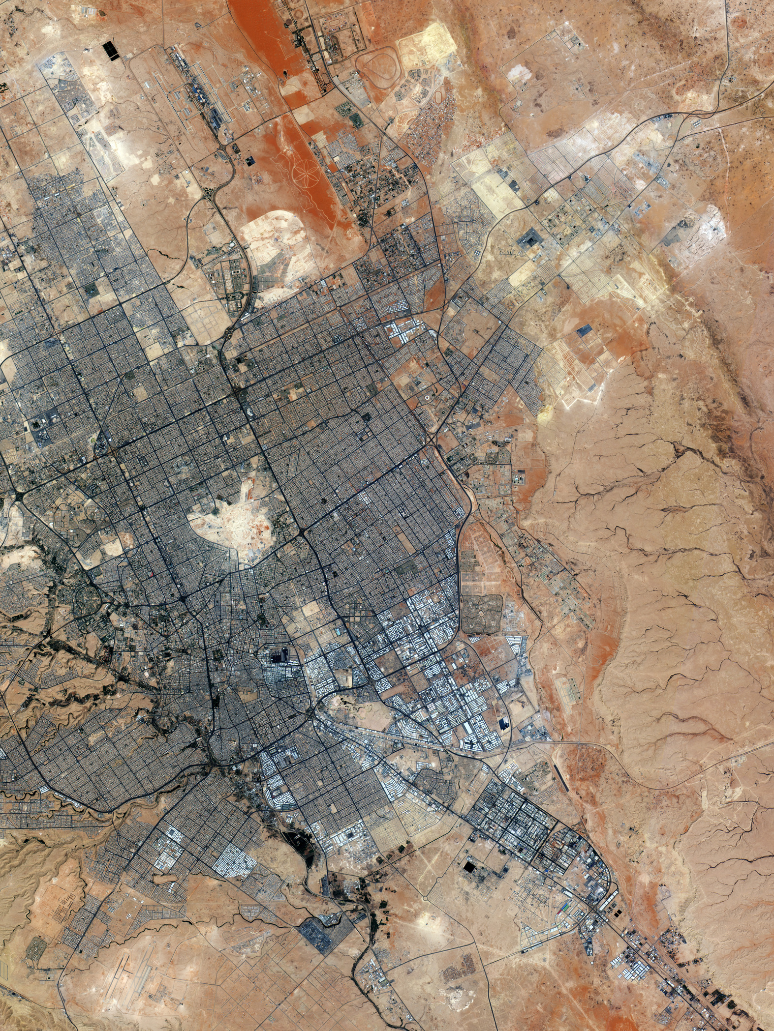
La missione Copernicus Sentinel-2 ci porta sopra Riyad, la capitale dell'Arabia Saudita.
Situata nella regione centrale dell'Arabia Saudita Riyad ospita oltre sette milioni di abitanti e funge da snodo legislativo, finanziario, amministrativo, diplomatico e commerciale della nazione.
Con una superficie approssimativamente di 1550 kmq la città si trova a circa 600 m sul livello del mare, sulla parte orientale dell'altopiano del Najd nella Penisola Arabica. Come gran parte dell'Arabia Saudita, Riyad ha un clima desertico con temperature estive estreme, che possono raggiungere i 50°C.
L'immagine presenta in primo piano il sistema stradale a griglia della città, che consiste in blocchi quadrati che misurano circa due km per lato, formando un'ampia rete che attraversa il paesaggio urbano.
Riyadh è servita dall'Aeroporto Internazionale King Khalid, situato a circa 35 km a nord della città, visibile in alto a sinistra dell'immagine.
Spostandosi verso sud-est il motivo floreale del cantiere del Sand Sports Park si staglia sul terreno sabbioso color arancione. Con una superficie di oltre 17 milioni di metri quadrati, la struttura fa parte del progetto su larga scala di Sports Boulevard, un parco lineare che si estende per 135 km attraverso tutta la città. Il progetto collegherà oltre 50 siti sportivi e sarà caratterizzato da piste ciclabili e pedonali, percorsi equestri ed escursionistici, oltre a diversi luoghi di intrattenimento.
La città possiede anche diversi grandi stadi, tra cui il King Fahd International Stadium, identificabile dalla sua struttura circolare bianca che può essere individuata zoomando a sud del Sand Sports Park.
Spostandosi ancora verso sud si può riconoscere la parte industriale della città grazie ai caratteristici tetti bianchi e brillanti.
Questa immagine, catturata il 14 settembre 2024, fa parte della straordinaria serie iniziale di immagini fornite da Copernicus Sentinel-2C, il terzo satellite della missione Sentinel-2. Sentinel-2C il 5 settembre 2024 si è unito ai suoi satelliti gemelli già in orbita, con l’obiettivo di garantire per il programma Copernicus la distribuzione continua di immagini ad alta risoluzione.
Scarica immagine HiRes (2,15 MB - .JPG)
Scarica immagine HiRes (78,71 MB - .TIF)
---
Riyad, Arabia Saudita
The Copernicus Sentinel-2 mission takes us over Riyadh, the capital city of Saudi Arabia.
Situated in the central region of Saudi Arabia, Riyadh serves as the nation’s legislative, financial, administrative, diplomatic and commercial hub, home to over seven million inhabitants.
Covering an area of around 1550 sq km, the city sits at approximately 600 m above sea level on the eastern part of the Najd plateau in the Arabian Peninsula. Like much of Saudi Arabia, Riyadh has a desert climate with extreme summer temperatures that can reach up to 50°C.
The image prominently features the city’s grid-like street system, which consists of square blocks measuring around two km one each side, forming an extensive network across the urban landscape.
Riyadh is served by the King Khalid International Airport, located approximately 35 km north of the city, visible in the top left of the image.
Moving southeast, the flower-like pattern of the Sand Sports Park construction site stands out against the orange, sandy terrain. Spanning more than 17 million sq m, the park is part of the large-scale Sports Boulevard Project, a linear park extending 135 km across the city. The project will connect over 50 sports sites and feature cycling and pedestrian pathways, equestrian and hiking trails, as well as several entertainment venues.
The city also has several large stadiums, including the King Fahd International Stadium, identifiable by its white circular structure, which can be spotted by zooming in south of the Sand Sports Park.
Towards the south, the industrial part of the city can be identified by the distinctive bright white rooftops.
This image, captured on 14 September 2024, is part of the stunning initial set of images delivered by Copernicus Sentinel-2C, the third satellite in the Sentinel-2 mission. Sentinel-2C joined its twin satellites in orbit on 5 September 2024, to ensure the continuous delivery of high-resolution imagery for the Copernicus programme.
[Credits: contains modified Copernicus Sentinel data (2024), processed by ESA - Translation: Gianluca Pititto]
