

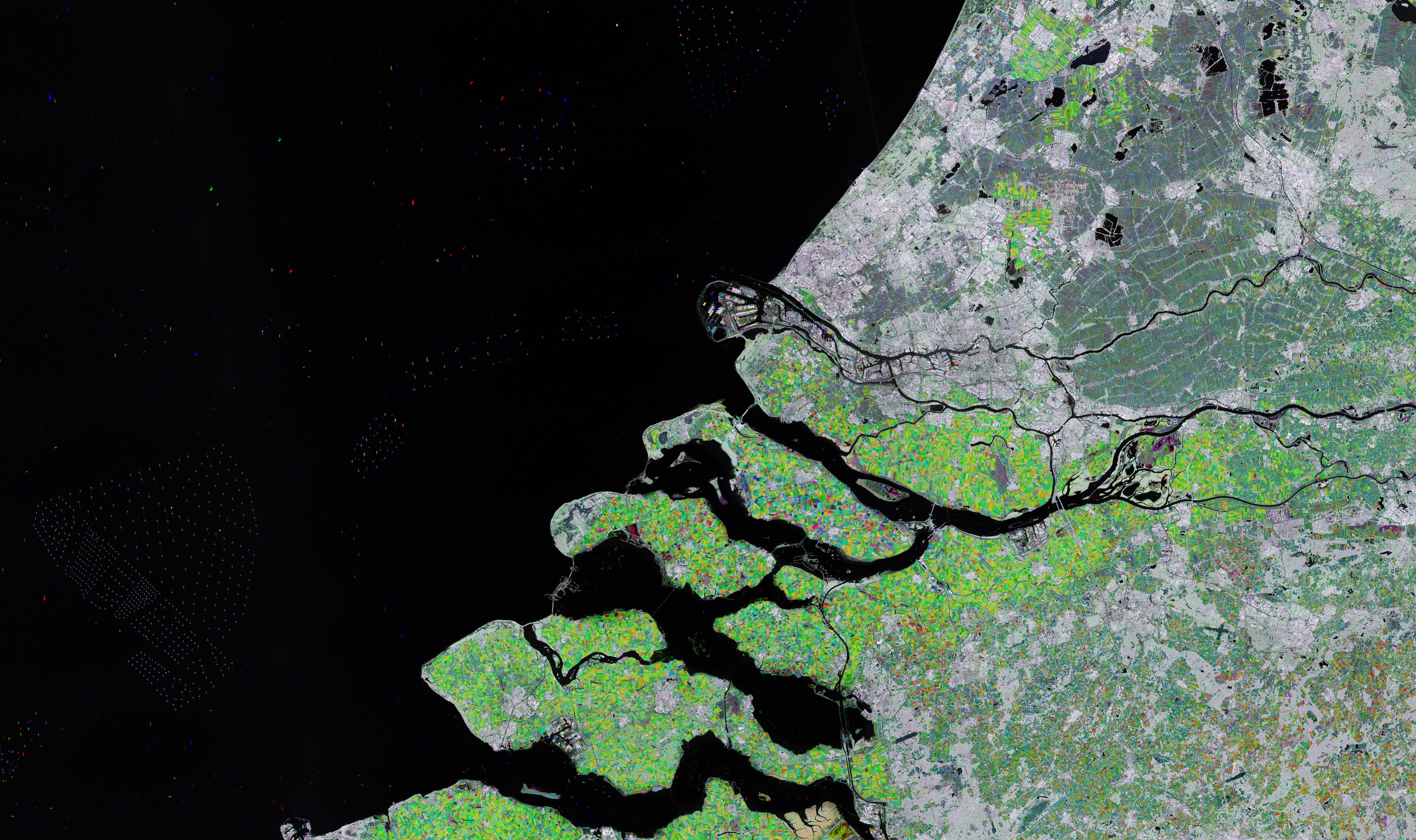
In questa immagine radar acquisita da Copernicus Sentinel-1 sono mostrati Rotterdam e parte della provincia della Zelanda, nel sud-ovest dei Paesi Bassi.
Questa immagine multi-temporale è stata generata con una combinazione di tre immagini radar, ognuna assegnata ad un differente canale cromatico: il rosso per l’immagine acquisita nell’agosto del 2022, il verde per la seconda immagine ottenuta nel gennaio del 2023 ed infine il blu per l’ultima risalente al giugno del 2023.
Le immagini combinate, con i loro differenti colori, aiutano ad identificare i cambiamenti avvenuti tra le varie acquisizioni. Ad esempio, il verde significa che la vegetazione era particolarmente lussureggiante quando l’immagine di gennaio è stata acquisita.
Le parti che appaiono di colore grigio o bianco descrivono cambiamenti piccoli o assenti. Le superfici idriche di regola appaiono scure o di colore nero.
I puntini colorati che appaiono sul nero del Mare del Nord sono imbarcazioni. I colori ci dicono quando sono stati rilevati dal satellite, in base a quanto descritto in precedenza. I punti bianchi sulla sinistra sono impianti eolici in mare.
Rotterdam, la seconda città del paese per estensione dopo Amsterdam, può essere riconosciuta come un’area grigia vicino al centro dell’immagine, a cavallo del fiume New Meuse, che appare come una linea di colore nero. Quello di Rotterdam è il più grande porto europeo ed è un punto di transito per 450 milioni di utilizzatori.
Altre città mostrate nell’immagine sono Utrecht a nordovest di Rotterdam e l’Aia a nordest sempre di Rotterdam. Muovendoci lungo la costa verso nord incontriamo la città di Noordwijk, che ospita la sede dell’ ESTEC, centro tecnico dell’ESA, dove vengono progettate le nuove missioni, ne viene gestito lo sviluppo industriale e dove in alcuni casi vengono anche effettuati i test sulle navicelle spaziali e sulle strumentazioni di bordo.
Il grande corpo idrico a sud di Rotterdam è Haringvliet. La diga di Haringvliet è visibile come un ponte bianco e verde sulla foce del fiume. La diga venne realizzata come parte del ‘Piano Delta’ - consistente in una molteplicità di dighe, chiuse, argini e sbarramenti atti a rinforzare la linea costiera. Anche la diga di Volkerak fa parte del piano ed è visibile nell’immagine all’estremo orientale di Haringvliet.
L’area mostrata nella parte inferiore dell’immagine è parte della provincia di Zeeland. Si estende su un vasto delta fluviale, originato dalla confluenza dei fiumi Schelde e Meuse, e consiste in un complesso sistema di isole, penisole e corsi d’acqua in gran parte al di sotto del livello del mare ed interconnessi grazie alle dighe ed ai ponti del ‘Piano Delta’.
Scarica immagine MedRes (10,86 MB - .JPG)
Scarica immagine HighRes (578 MB - .TIF)
---
Southwest Netherlands
Rotterdam and part of the Zeeland province in southwest Netherlands are featured in this radar image acquired by Copernicus Sentinel-1.
This multitemporal picture is a combination of three radar images, each assigned to a colour channel: red for the image acquired in August 2022, green for the second image taken in January 2023, and blue for the last image from June 2023.
The combined images, with their different colours, help identify changes that have occurred between the acquisitions. For example, the green means that the vegetation was particularly lush when the January image was acquired.
Parts that appear grey or white depict little or no change. Water surfaces usually appear dark or black.
The coloured dots in the black of the North Sea are ships. Their colours indicate when they were captured by the satellite, as noted above. The white dots on the left are offshore wind farms.
Rotterdam, the country’s second largest city after Amsterdam, can be seen as a grey area near the centre of the image, straddling the New Meuse River, visible as a black line. Rotterdam is Europe’s largest port and the gateway to some 450 million customers.
Other cities pictured include Utrecht northwest of Rotterdam and The Hague northeast of Rotterdam. Moving north along the coast lies the town of Noordwijk, which is home to ESTEC, ESA’s technical centre, where new missions are designed, their industrial development is managed and, in some cases, the spacecraft and instruments are tested.
The large body of water south of Rotterdam is Haringvliet. Haringvliet dam is visible as a white and green bridge closing the mouth of the river. The dam was constructed as part of the ‘Delta Plan’ – a number of dams, sluices, dikes and barriers to reinforce the coastline. Volkerak dam also part of the plan, is visible in the image at the eastern end of Haringvliet.
The area featured at the bottom of the image is part of the province of Zeeland. It lies on a large river delta, formed by the confluence of the Schelde and Meuse rivers and consists of a complex system of islands, peninsulas and waterways, mostly below sea level and interconnected by the dams and bridges of the Delta Works.
[Credits: contains modified Copernicus Sentinel data (2022-2023), processed by ESA - Translation: Gianluca Pititto]
