

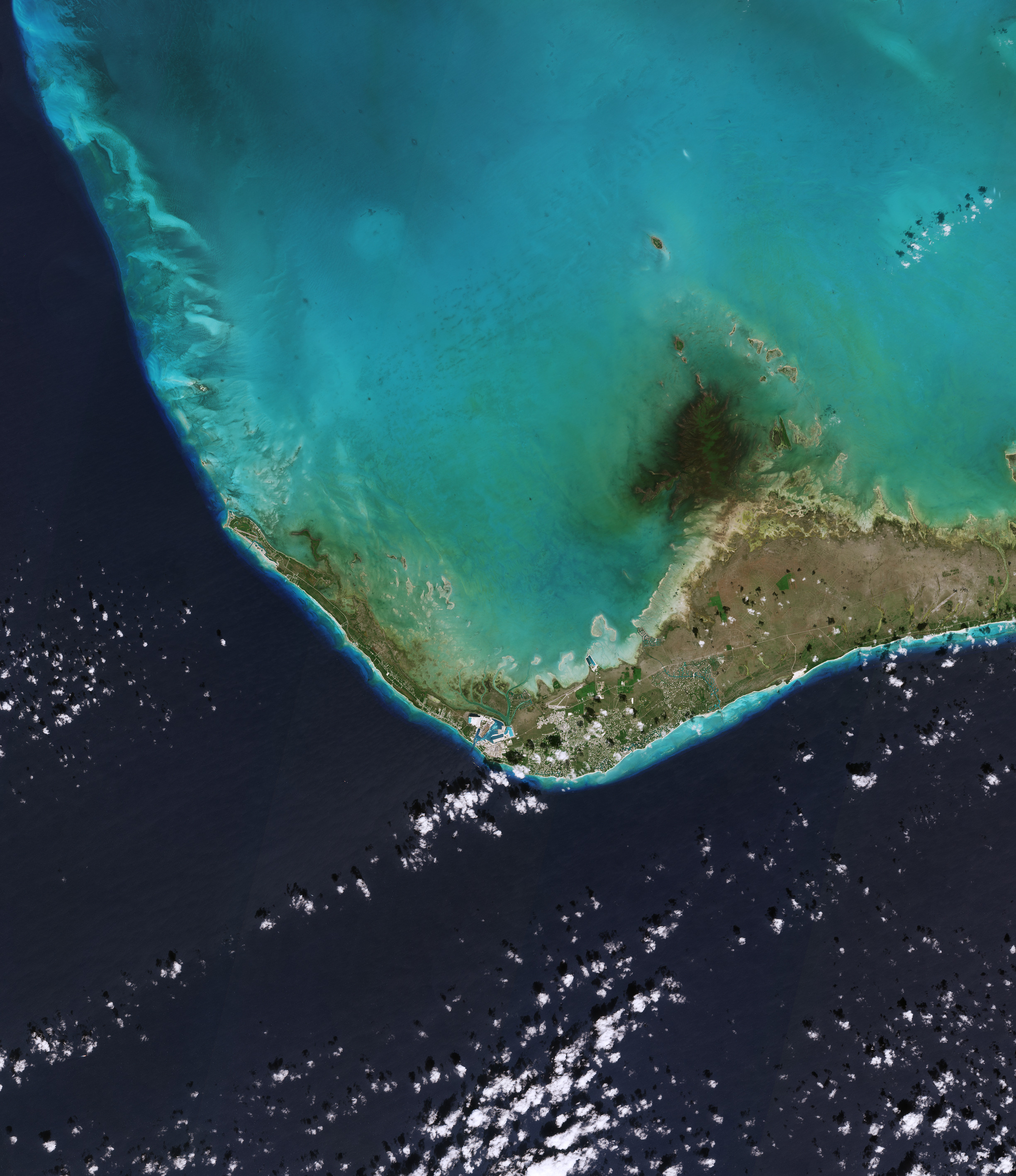
In vista della Giornata Mondiale degli Oceani, la missione Copernicus Sentinel-2 ci porta sopra la parte occidentale dell'isola di Grand Bahama, alle Bahamas.
Situata nell'Oceano Atlantico a circa 100 km a est dello stato americano della Florida, Grand Bahama è l'isola più settentrionale delle Bahamas e la terza più grande dell'arcipelago. Le due città principali di Grand Bahama sono entrambe visibili nell'immagine: West End sulla punta nord-occidentale dell'isola e Freeport sulla costa meridionale.
West End è la città più antica dell'isola ed è anche la capitale. La pista dell'aeroporto di West End, il più piccolo dei due aeroporti che servono Grand Bahama, può essere individuata a ovest della città.
Freeport, che è stata costruita poco più di tre decenni fa su quella che era un'area coperta da una pineta, è ora un fiorente porto, centro industriale e destinazione turistica. Ora è anche la seconda città più popolosa delle Bahamas. Ingrandendo, l'Aeroporto Internazionale di Grand Bahama è visibile a nord della città, mentre il porto - il secondo porto per navi da crociera più grande delle Bahamas - si staglia ad ovest.
Le acque turchesi e poco profonde che circondano l'isola contrastano fortemente con il profondo blu dell'oceano aperto, che domina la parte inferiore dell'immagine.
La Giornata Mondiale degli Oceani, che si celebra l'8 giugno di ogni anno, è un'opportunità per celebrare l'oceano, la sua vita rigogliosa, la sua importanza e le modalità tramite le quali possiamo proteggere e recuperare le sue risorse.
Coprendo oltre il 70% della superficie terrestre, gli oceani della Terra sono ciò che rende blu questo pianeta. I nostri mari influenzano il clima, producono la maggior parte dell'ossigeno che respiriamo, fungono da mezzo di trasporto e da importante fonte di cibo e risorse.
Purtroppo, l'oceano non è più quello di una volta. Molte delle attività nel mondo legate alla pesca sono in declino, gli ecosistemi corallini si stanno deteriorando, i fragili habitat costieri vengono soffocati dall'inquinamento e il cambiamento climatico sta prendendo il sopravvento, portando a acque superficiali più calde e cambiando la chimica delle acque.
I satelliti per l'osservazione della Terra acquisiscono dati su tutto il nostro pianeta: dati che aumentano la nostra comprensione scientifica e supportano una serie di servizi di monitoraggio ambientale a sostegno della conservazione degli oceani.
Scarica immagine HiRes (13,05 MB - .JPG)
Scarica immagine HiRes (333,77 MB - .TIFF)
---
Grand Bahama Island
Ahead of World Ocean Day, the Copernicus Sentinel-2 mission takes us over the west of Grand Bahama Island, in the Bahamas.
Located in the Atlantic Ocean about 100 km east of the US state of Florida, Grand Bahama is the northernmost island in the Bahamas and the third largest in the archipelago. Grand Bahama’s two main cities are both visible in the image: West End on the northwestern tip of the island and Freeport on the southern shore.
West End is the oldest city on the island, and the capital. The runway of West End airport, the smaller of the two airports serving Grand Bahama, can be spotted west of the city.
Freeport, which has been built on what was an area covered by pine forest a little over three decades ago, is now a thriving port, industrial centre and tourist destination. It is now also the second most populous city in The Bahamas. Zooming in, the Grand Bahama International Airport is visible north of the city, while the port, the second-largest cruise port in The Bahamas, stands out to the west.
The shallow, turquoise waters surrounding the island contrast sharply with the deep blue of the open ocean, which dominates the bottom part of the image.
Taking place on 8 June each year, World Ocean Day is an opportunity to celebrate the ocean – its abundant life, its importance and how we can protect and restore its resources.
Covering more than 70% of Earth’s surface, Earth's oceans are what makes this a Blue Planet. Our seas influence the climate, produce most of the oxygen we breathe, serve as a means of transport and a major source of food and resources.
Unfortunately, the ocean is no longer as it once was. Many of the world's fisheries are in decline, coral ecosystems are deteriorating and fragile coastal habitats being choked by pollution, and climate change is taking its toll leading to warmer surface waters and changing the chemistry of the waters.
Earth observing satellites acquire data across our planet that increase our scientific understanding and support a range of environmental monitoring services backing ocean conservation.
[Credits: contains modified Copernicus Sentinel data (2023), processed by ESA - Translation: Gianluca Pititto]
