

Copernicus Sentinel-1 ha catturato questa immagine radar sopra la Guyana Francese, sede dello spazioporto europeo di Kourou, dove la missione Biomass dell'ESA è in fase di preparazione per il decollo previsto per il 29 aprile a bordo di un razzo Vega-C.
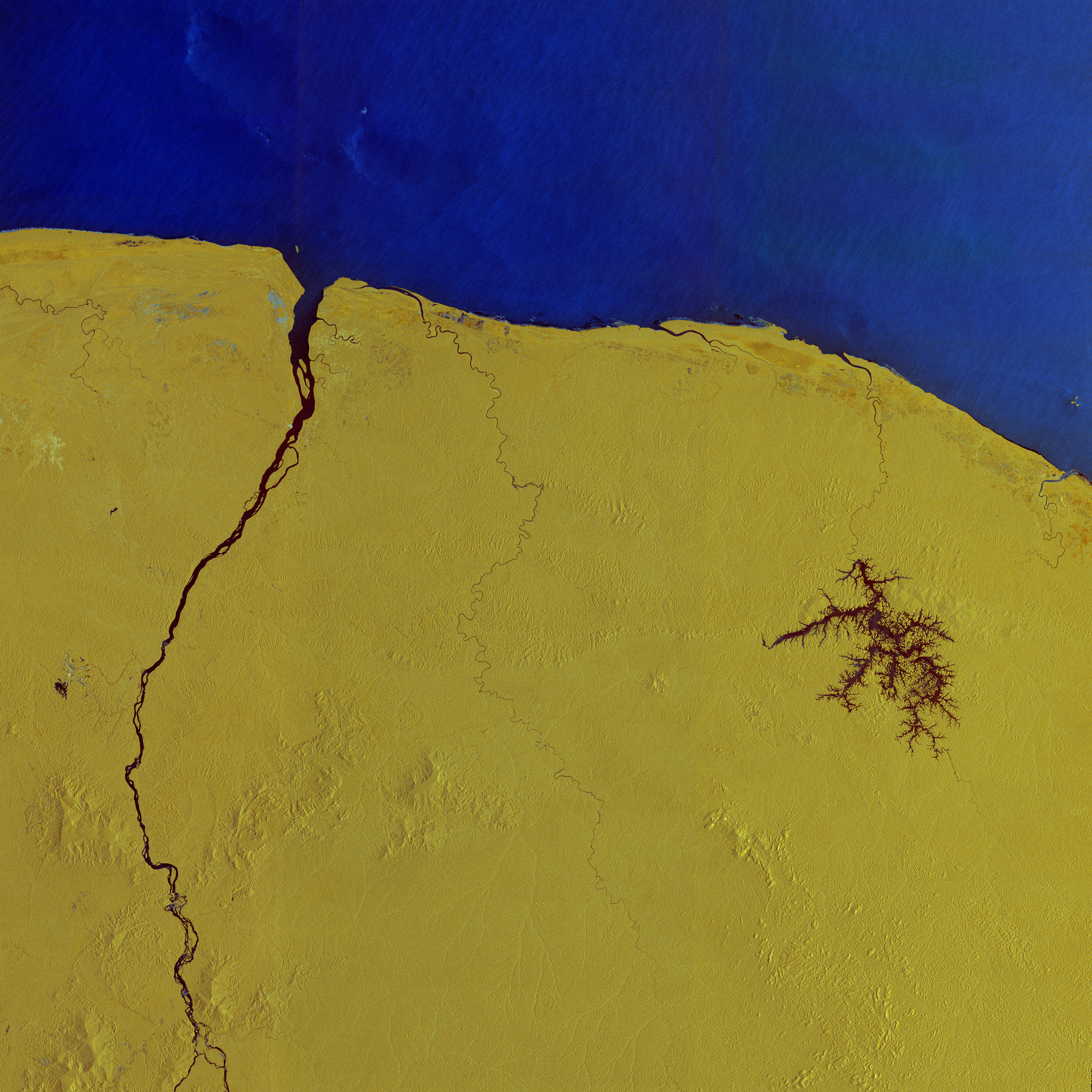
Questa veduta a falsi colori mostra parte della costa nord-orientale del Sud America, dall'estuario del fiume Kourou nella Guyana Francese a est, fino al Suriname ad ovest del fiume Maroni. Quest'ultimo è visibile come una linea scura, che si snoda attraverso l'immagine e segna il confine tra i due paesi.
I colori mostrati provengono dalla combinazione di due polarizzazioni utilizzate dall missione Copernicus Sentinel-1, a ciascuna delle quali è stato assegnato un colore e poi successivamente convertite in un unico composito. Questa tecnica di elaborazione aiuta a distinguere diversi tipi di superficie, fornendo in tal modo informazioni dettagliate.
Qui l'acqua si riflette chiaramente con tonalità blu scure. Nell'Oceano Atlantico si possono osservare differenti motivi d'onda, giacchè il segnale radar è altamente sensibile ai cambiamenti nella rugosità dell'acqua: le acque calme appaiono più scure, mentre il mare mosso appare più luminoso.
Al centro ed a destra dell'immagine spiccano corsi d'acqua scuri e ramificati del bacino idrico di Petit Saut. Il corpo idrico è formato da una diga idroelettrica costruita sul fiume Sinnamary. Il fiume si osserva nel suo serpeggiare verso nord per poi sfociare nell'Oceano Atlantico.
La maggior parte del terreno è mostrata in vivaci tonalità di giallo, che indicano le foreste pluviali tropicali e altre aree di vegetazione, dove il segnale radar interagisce e rimbalza sulla complessa struttura della chioma - inclusi tronchi d'albero, rami e foglie. I centri abitati appaiono più colorati rispetto all'ambiente circostante.
Con oltre il 90% del territorio coperto da foreste, la Guyana Francese è il territorio con il maggior numero di alberi per abitante al mondo. Dal momento che è un dipartimento d'oltremare della Francia, è anche l'unica parte della foresta amazzonica interna alla UE.
Lo spazioporto europeo si trova a nord-est del bacino idrico di Petit Saut, sulla costa tra l'estuario del fiume Sinnamary e il fiume Kourou. Questo è il sito che ospita le famiglie di razzi Ariane e Vega sviluppate dall'ESA e consente all'Europa un accesso indipendente e affidabile allo spazio.
Da qui è previsto per il 29 aprile il lancio della missione Biomass dell'ESA su un razzo Vega-C.
Una volta in orbita, la più recente missione Earth Explorer fornirà informazioni vitali sulla salute e sulle dinamiche delle foreste del mondo, rivelando come stanno cambiando nel tempo e, soprattutto, migliorando la nostra comprensione del loro ruolo nel ciclo globale del carbonio e, pertanto, nel sistema climatico.
Scarica immagine HiRes (61,88 MB - .JPG)
Scarica immagine HiRes (1,5 GB - .TIF)
---
French Guiana
Copernicus Sentinel-1 captured this radar image over French Guiana – home to Europe’s Spaceport in Kourou, where ESA’s Biomass mission is being prepared for liftoff on 29 April onboard a Vega-C rocket.
This false-colour view shows part of the northeast coast of South America, stretching from the estuary of the Kourou River in French Guiana in the east, to Suriname, west of the Maroni River. The latter is visible as a dark line, snaking its way across the image and marking the border between the two countries.
The colours in this image come from the combination of two polarisations from the Copernicus Sentinel-1 mission, which have been assigned a colour and converted into a single composite. This processing technique helps to distinguish different types of surface, thereby providing detailed information.
Here, water is clearly reflected in dark shades of blue. Distinct wave patterns can be seen in the Atlantic Ocean since the radar signal is highly sensitive to changes in the roughness on the water: calm waters appear darker, while rough seas appear brighter.
The dark, branching waterways of the Petit Saut Reservoir stand out in the centre-right of the image. The water body is formed by a hydroelectric dam built on the Sinnamary River. The river can be seen winding its way north to eventually drain into the Atlantic Ocean.
Most of the land is shown in vibrant shades of yellow, indicating tropical rainforests and other areas of vegetation, where radar signal interacts and bounces from the complex structure of the canopy, including tree trunks, branches and leaves. Built-up areas appear more colourful than the surroundings.
With over 90% of land covered by forest, French Guiana is the territory with the most trees per inhabitant in the world. Since it is an overseas department of France, it is also the only part of the Amazonian forest in the EU.
Northeast of the Petit Saut Reservoir, on the coast between the estuary of the Sinnamary River and the Kourou River, lies Europe's Spaceport. This is home to the ESA-developed Ariane and Vega rocket families and allows for independent, reliable access to space for Europe.
From here, ESA’s Biomass mission is scheduled to launch on a Vega-C rocket on 29 April.
Once in orbit, this latest Earth Explorer mission will provide vital insights into the health and dynamics of the world’s forests, revealing how they are changing over time and, critically, enhancing our understanding of their role in the global carbon cycle, and hence in the climate system.
[Credits: contains modified Copernicus Sentinel data (2025), processed by ESA - Translation: Gianluca Pititto]
