

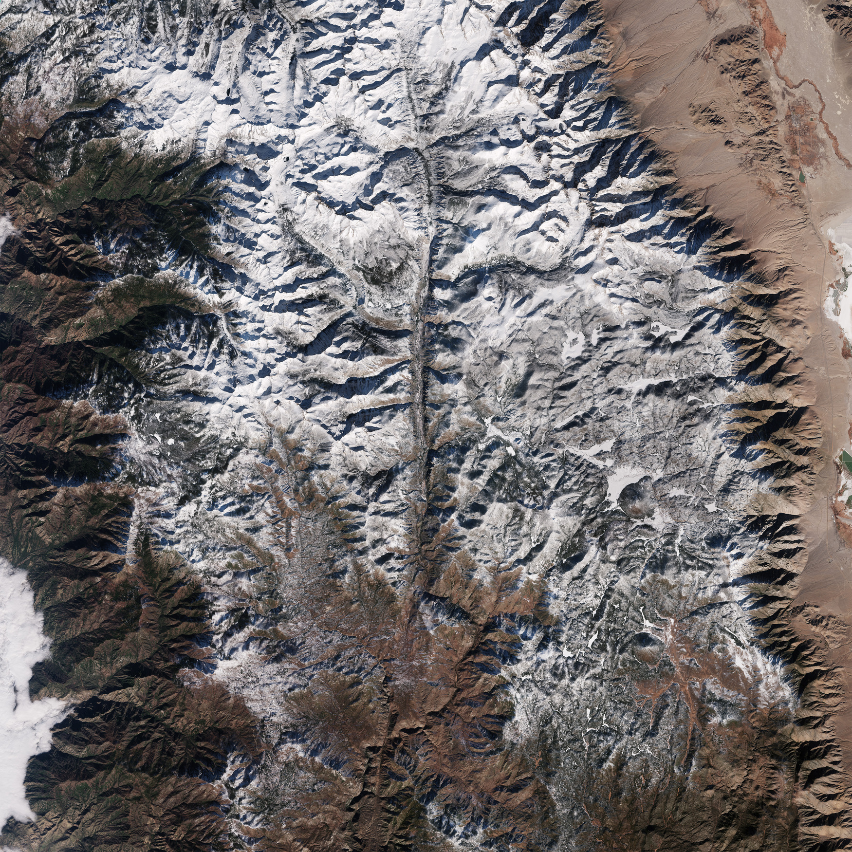
La missione Copernicus Sentinel-2 ci porta sopra i Parchi Nazionali di Sequoia e Kings Canyon nelle montagne della Sierra Nevada, in California.
L'area qui mostrata è la Sierra Nevada meridionale, una grande catena montuosa nel Nord America occidentale, che corre lungo il confine orientale della California. La regione è caratterizzata da drastici cambiamenti di altezza, che vanno da circa 418 metri ai piedi delle colline a oltre 4400 metri del Monte Whitney, la vetta più alta degli Stati Uniti al di fuori dell'Alaska (visibile in alto a destra).
L'immagine mostra a sud una parte rilevante del Sequoia National Park e una porzione più piccola del Kings Canyon National Park a nord. Poiché questa immagine è stata scattata nel dicembre 2024, entrambi i parchi sono in gran parte ricoperti di neve.
I due parchi sono uno accanto all'altro e gestiti come un unico parco nazionale, che comprende una grande area di circa 3500 kmq. Il Sequoia National Park copre circa 1630 kmq e il Kings Canyon circa 1870 kmq.
Il variegato paesaggio dei parchi è caratterizzato da enormi montagne, aspre colline, profondi canyon, vaste caverne e fitte foreste di conifere piene di boschi di sequoie giganti. Le sequoie giganti sono tra gli alberi più grandi e antichi del mondo e crescono solo sulle pendici occidentali della Sierra Nevada tra i 900 e i 2600 m.
La sequoia più grande, nota come General Sherman Tree, è alta circa 84 m, ha un tronco di oltre 30 m di circonferenza e si pensa che abbia fino a 2700 anni. Si trova in una sezione del Sequoia National Park, chiamata Giant Forest, visibile nell'angolo in alto a sinistra dell'immagine.
Le foreste, spesso chiamate 'polmoni verdi della Terra', sono una parte cruciale del ciclo del carbonio della Terra, poiché assorbono e immagazzinano grandi quantità di carbonio dall'atmosfera ogni anno, contribuendo così a mantenere il nostro pianeta fresco ed a regolare il clima.
Tuttavia, la combustione di combustibili fossili, la deforestazione ed il degrado forestale, in particolare nelle regioni tropicali, stanno determinando il rilascio nell'atmosfera del carbonio immagazzinato, esasperando il cambiamento climatico.
L’imminente missione forestale dell'ESA, Biomass, il cui lancio è previsto per la fine di aprile 2025, fornirà nuove informazioni sullo stato delle nostre foreste e su come stanno cambiando: approfondirà la nostra conoscenza del ruolo che le foreste svolgono nel ciclo del carbonio e quindi nel complesso del sistema climatico.
Scarica immagine HiRes (6,53 MB - .JPG)
Scarica immagine HiRes (273,56 MB - .TIF)
---
Land of Giants
The Copernicus Sentinel-2 mission takes us over the Sequoia and Kings Canyon National Parks in California’s Sierra Nevada mountains.
The area pictured here shows the southern Sierra Nevada, a large mountain range in western North America that runs along the eastern edge of California. The region is defined by dramatic changes in height, ranging from about 418 m in the foothills to over 4400 m at Mount Whitney, the highest peak in the United States outside of Alaska, visible in the top right of the image.
The image showcases a big part of the Sequoia National Park to the south and a smaller portion of the Kings Canyon National Park to the north. Since this image was captured in December 2024, both parks are largely blanketed in snow.
The two parks are next to each other and managed as one national park, which encompasses a vast area of about 3500 sq km. Sequoia National Park covers approximately 1630 sq km and Kings Canyon about 1870 sq km.
The parks’ diverse landscape feature huge mountains, rugged foothills, deep canyons, vast caverns and dense conifer forests filled with groves of giant sequoias. Giant sequoias are among the world’s largest and oldest trees and grow only on the western slopes of the Sierra Nevada at between 900 and 2600 m.
The largest sequoia, known as the General Sherman Tree, is about 84 m tall, has a trunk over 30 m in circumference and is thought to be up to 2700 years old. It stands in a section of the Sequoia National Park, called the Giant Forest, visible in the top left corner of the image.
Forests, often called ‘Earth’s green lungs’, are a crucial part of Earth’s carbon cycle, since they absorb and store large amounts of carbon from the atmosphere each year – thereby helping to keep our planet cool and regulate the climate.
However, the burning of fossil fuels, deforestation and forest degradation, particularly in tropical regions, are causing stored carbon to be released back into the atmosphere, exacerbating climate change.
ESA’s upcoming forest mission, Biomass, set for launch at the end of April 2025, will provide new insight into the state of our forests and how they are changing, and further our knowledge of the role forests play in the carbon cycle, and hence in the climate system.
[Credits: contains modified Copernicus Sentinel data (2024), processed by ESA - Translation: Gianluca Pititto]
