

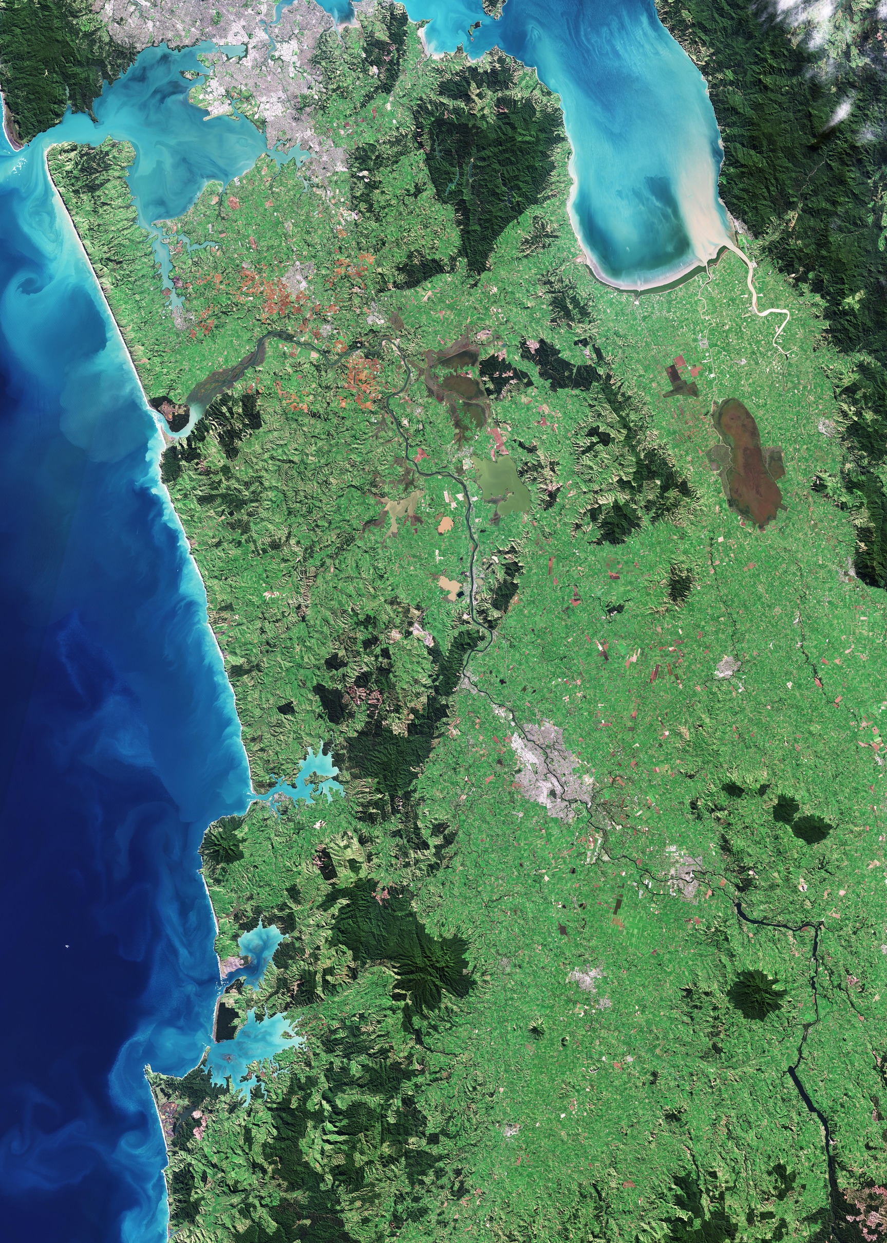
Acquisita il 7 maggio 2024, questa immagine di Copernicus Sentinel-2 mostra parte dell'Isola del Nord della Nuova Zelanda.
La Nuova Zelanda si trova nell'Oceano Pacifico meridionale e comprende due isole principali: la Nord e la Sud, in aggiunta ad un certo numero di isole minori.
In questa immagine si può osservare come gran parte del territorio dell'Isola del Nord sia dominato da una vegetazione lussureggiante, con aree verdi più scure che denotano dense zone boschive.
I centri urbani appaiono di colore grigio. Verso la parte superiore dell'immagine, la città di Auckland può essere riconosciuta come una grande area grigia, adiacente al golfo di Hauraki ad est ed al porto di Manukau a ovest. Auckland è la città più popolosa del paese ed ospita il porto più grande della nazione. Punto focale per i trasporti, la città è servita anche dal principale aeroporto internazionale della Nuova Zelanda, che si può osservare al centro del porto di Manukau.
Spostandosi verso sud, la più grande zona grigia al centro dell'immagine è Hamilton, uno dei centri interni più importanti del paese. Si trova a cavallo del fiume Waikato, il fiume più lungo della Nuova Zelanda, che può essere intravisto come una linea scura e sinuosa in basso a destra nell'immagine e che divide Hamilton in due parti quasi simmetriche.
Mentre disegna il suo corso il Waikato si snoda attraverso un mosaico di campi agricoli che coprono la pianura tra Auckland e Hamilton. Le tonalità verdi e marroni dei campi mutano a seconda del tipo di coltura e dei loro vari stadi di crescita.
Prima di entrare nel Mar di Tasmania, a sud di Auckland il fiume Waikato forma un estuario, che alimenta una rete di paludi e crea numerose piccole isole.
Sulla costa le tonalità turchese brillante del Mar di Tasmania suggeriscono la presenza di sedimenti trasportati nell'oceano dal riversamento dei fiumi. I vortici nel mare mostrano come le correnti trasportano i sedimenti.
Un certo numero di laghi e zone umide possono essere individuati vicino al centro dell'immagine, includendo la zona umida di Whangamarino, un vasto mosaico di paludi e torbiere, visibile come un'area marrone scuro ad est del fiume Waikato. Il Kopuatai Peat Dome, la più grande ed intatta torbiera della Nuova Zelanda, è chiaramente visibile come la formazione marrone allungata appena a sud del golfo di Hauraki.
Scarica immagine HiRes (7,45 - .JPG)
Scarica immagine HighRes (829,78 - .TIF)
---
New Zealand’s North Island
Captured on 7 May 2024, this Copernicus Sentinel-2 image shows part of New Zealand’s North Island.
New Zealand lies in the South Pacific Ocean and comprises two major islands – North and South – and a number of smaller islands.
Much of North Island’s terrain in this image is dominated by lush vegetation, with darker green areas denoting dense forested zones.
Urban centres appear in grey. Towards the top of the image, the city of Auckland can be seen as a large, grey area adjacent to the Hauraki Gulf to the east and the Manukau Harbour to the west. Auckland is the country’s most populous city and its largest port. A focal point for transportation, the city is also served by New Zealand’s leading international airport, which can be spotted in the centre of Manukau Harbour.
Moving south, the largest grey area in the middle of the image is Hamilton, one of the country’s most important inland centres. It straddles the Waikato River, the longest river in New Zealand, which can be seen as a dark, winding line across the bottom right of the image, bisecting Hamilton into two nearly symmetrical parts.
As it winds its course, the Waikato meanders through a patchwork of agricultural fields that cover the plain between Auckland and Hamilton. The green and brown hues of the fields shift according to the crop type and their various stages of growth.
Before entering the Tasman Sea, south of Auckland, the Waikato River forms an estuary, which feeds a network of marshes and creates numerous small islands.
On the coast, bright, turquoise colours in the Tasman Sea suggest the presence of sediment being carried into the ocean by river discharge. The swirls in the sea show how the currents transport sediment.
A number of lakes and wetlands can be spotted near the centre of the image, including the Whangamarino Wetland, an extensive mosaic of swamps and bogs, visible as a dark brown area east of the Waikato River. The Kopuatai Peat Dome, the largest, unaltered peat bog in New Zealand, is clear to see as the brown, elongated feature just south of the Hauraki Gulf.
[Credits: contains modified Copernicus Sentinel data (2024), processed by ESA - Translation: Gianluca Pititto]
