

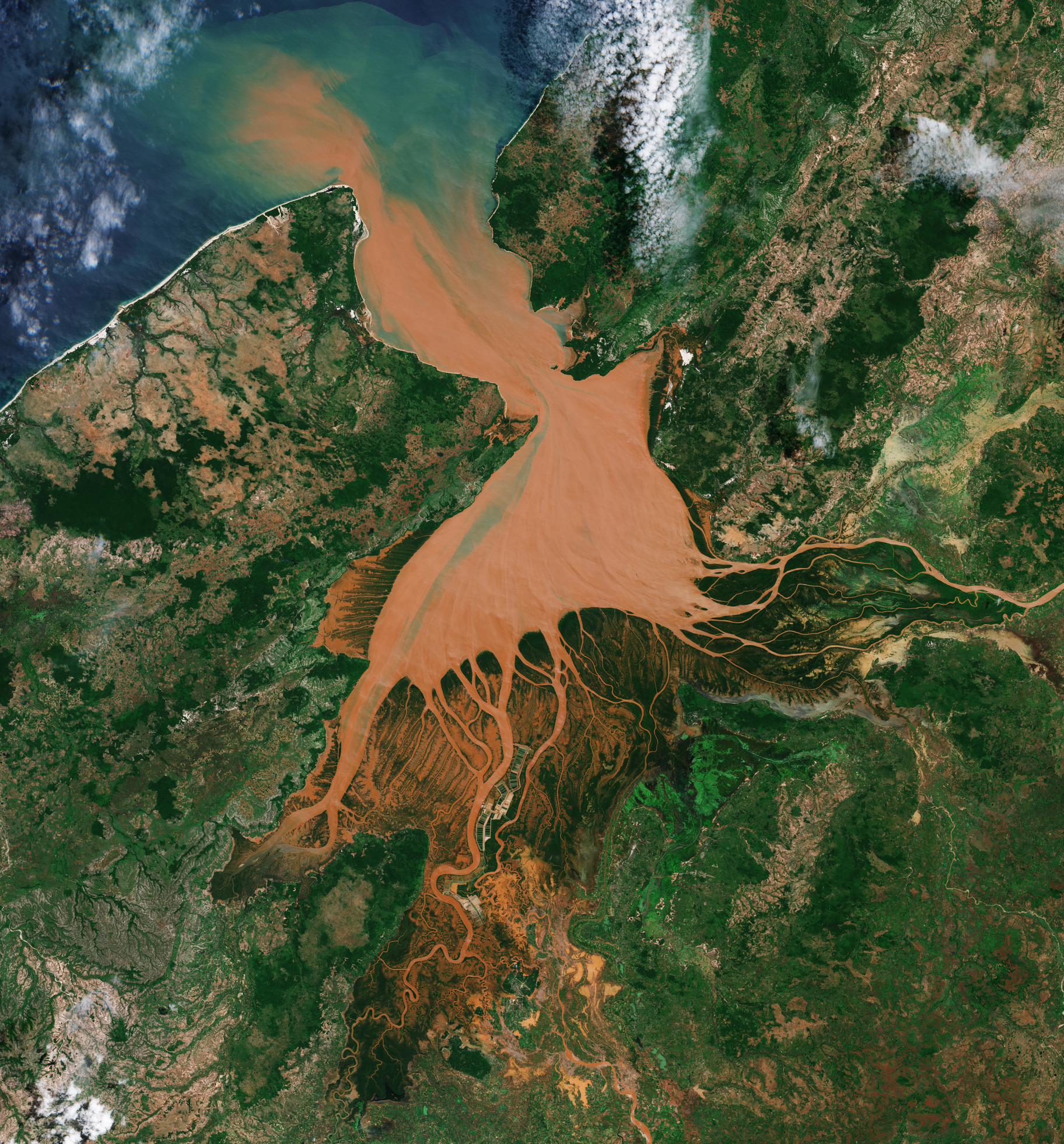
Simile a una medusa rossastra, la baia di Mahajamba in Madagascar è qui ripresa da Copernicus Sentinel-2.
Il Madagascar è la quarta isola più grande del mondo, Situata nell'Oceano Indiano al largo della costa orientale dell'Africa e conta una superficie di quasi 600.000 kmq.
La baia di Mahajamba, nota anche come Helodrano Mahajambe, si trova nel nord-ovest del Madagascar alla confluenza di due grandi fiumi: il Mahajamba, che entra da sud, ed il fiume Sofia, che scorre da nord-est. Entrambi i fiumi sfociano poi nel Canale del Mozambico, che separa il Madagascar dal continente africano.
Il sistema fluviale Mahajamba, come altri sistemi fluviali del Madagascar occidentale, si distingue per la sua acqua di colore rossastro causata dai sedimenti provenienti da monte. Durante le forti piogge, i terreni rosso vivo vengono dilavati dalle colline in ruscelli e fiumi, raggiungendo infine la costa. Questa circostanza è stata anche individuata dagli astronauti sulla ISS, che lo hanno descritto come "sanguinamento nell'oceano". Tuttavia, le acque della baia non sono sempre rosse: una combinazione di maree e mancanza di precipitazioni consistenti possono schiarire rapidamente le acque.
Ingrandendo i "tentacoli delle meduse" vicino al centro dell'immagine si notano modelli di coltivazione e gestione del suolo, così come una pista di atterraggio vicino a Besakoa, l'insediamento più importante che appare visibile.
Il Madagascar ospita specie rare di flora e fauna, avendo sviluppato i propri ecosistemi e la propria fauna selvatica da quando si è separato dal continente africano circa 160 milioni di anni fa. La baia di Mahajamba ospita i più grandi ecosistemi di mangrovie della costa occidentale del Madagascar. Lungo le coste del Madagascar le mangrovie sono il tipo di vegetazione più predominante, fornendo rifugio alle comunità di molluschi e crostacei e fungendo da habitat per tartarughe marine, dugonghi ed uccelli.
Oltre alle mangrovie, qui si possono trovare alcuni dei sistemi di barriere coralline più estesi del mondo e una vasta gamma di uccelli, lemuri e molte altre specie. Tuttavia, preservare l'impressionante biodiversità del paese è una sfida continua.
Si ritiene che la perdita di suolo dovuta alla deforestazione per via della coltivazione e del pascolo rappresenti una seria minaccia per gli habitat dell'isola. Inoltre il commercio illegale di fauna selvatica è un'ulteriore sfida.
Il Madagascar è riconosciuto come uno degli hotspot a più alta priorità per la biodiversità, con numerose organizzazioni internazionali di conservazione che lavorano insieme per preservare l'ecosistema unico dell'isola.
Scarica immagine HiRes (1,90 MB - .JPG)
Scarica immagine HiRes (40,95 MB - .TIFF)
---
Madagascar jellyfish
Resembling a reddish jellyfish, the Mahajamba Bay in Madagascar is imaged by Copernicus Sentinel-2.
Located in the Indian Ocean off the east coast of Africa and covering almost 600 000 sq km, Madagascar is the fourth largest island in the world.
The Mahajamba Bay, also known as Helodrano Mahajambe, lies in northwest Madagascar at the confluence of two major rivers: the Mahajamba entering from the south and the Sofia River flowing from northeast. Both rivers then empty into the Mozambique Channel, which separates Madagascar from the African continent.
The Mahajamba river system, as with other river systems in western Madagascar, is distinctive for its reddish-coloured water caused by sediment from upstream. During heavy rain, the bright red soils are washed from hills into streams and rivers, eventually reaching the coast. This has also been spotted by astronauts on the ISS, who have described it as “bleeding into the ocean.” However, the bay waters are not always red – a combination of tides and lack of substantial rainfall can quickly clear the waters.
Zooming into the ‘jellyfish tentacles’ near the centre of the image reveals patterns of cultivation and land management, as well as an airstrip near Besakoa, the most prominent settlement visible.
Madagascar is home to rare flora and fauna, having developed its own ecosystems and wildlife since splitting from the African continent some 160 million years ago. The Mahajamba Bay is home to the largest mangrove ecosystems on Madagascar’s west coast. Along Madagascar’s coastlines, mangroves are the most predominant kind of vegetation, providing shelter for mollusc and crustacean communities and serving as a habitat for sea turtles, dugongs and birds.
In addition to mangroves, some of the world’s most extensive coral reef systems and a vast array of birds, lemurs, and many other species can be found here. However, preserving the country’s impressive biodiversity is an ongoing challenge.
Loss of soil through deforestation for cultivation and pasture is believed to pose a serious threat to the island’s habitats, and the illegal wildlife trade is a further challenge.
Madagascar is recognised as one of the highest priority hotspots for biodiversity, with numerous international conservation organisations working together to preserve the island’s unique ecosystem.
[Credits: contains modified Copernicus Sentinel data (2024), processed by ESA - Translation: Gianluca Pititto]
