

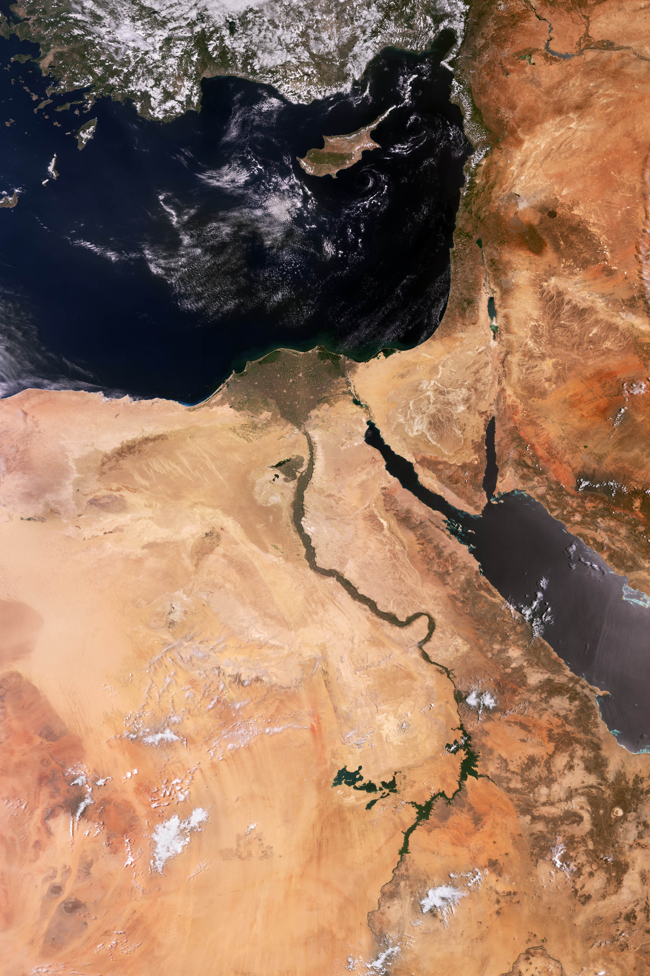
L’ampia visuale di Sentinel-3 ci mostra il confine orientale del Mediterraneo e le nazioni ad esso limitrofe.
Questa ampia vista include l’Egitto a sud ed Israele, Giordania, Libano e Siria ad est. Parte dell’Arabia Saudita può essere riconosciuta ad est del Mar Rosso ed il Sudan ad ovest di esso. A nord si può osservare l’isola di Cipro e la costa meridionale della Turchia.
Il verde traingolo del fertile delta del Nilo in Egitto contrasta con il nudo deserto circostante. Giacchè meno del 3% del territorio egiziano è utilizzabile per le coltivazioni, il delta costituisce una regione agricola molto importante.
Il Cairo, capitale dell’Egitto, appare con una colorazione grigio-marrone in fondo all’area del delta.
Il fiume Nilo è visibile con chiarezza. Scorrendo per circa 6650 km il Nilo è il fiume più lungo al mondo. Questo possente corso d'acqua nasce a sud dell’equatore e scorre verso nord attraverso l’Africa nord-orientale, prima di riversarsi nel Mar Mediterraneo.
Il Mar Rosso è ben visibile in questa immagine. E’ collegato al Mediterraneo tramite il Canale di Suez, una delle tratte marine più importanti al mondo, che fornisce un collegamento diretto tra il Mar Mediterraneo e l’Oceano Indiano.
Il bacino idrico più piccolo al centro ed a destra dell’immagine è il Mar Morto, il punto più basso della superficie terrestre e dieci volte più salato dell’acqua in mare apero.
L’area color verde chiaro a sud del Mar Morto è un largo complesso di bacini di evaporazione, che produce sale per l’industria chimica e per il consumo umano.
Copernicus Sentinel-3 osserva il pianeta in cui abitiamo allo scopo di comprendere le dinamiche ambientali su larga scala. Basato su una costellazione di due satellite identici, la missione trasporta un insieme di strumenti atti ad effettuare misure sui nostri oceani, sul territorio, sull’atmosfera e sui ghiacci, allo scopo di fornire informazioni critiche per una gamma di applicazioni che vanno dalle osservazioni marine al monitoraggio di ampie aree di vegetazione.
Scarica immagine MedRes (2,10 MB - .JPG)
Scarica immagine HighRes (93,14 MB - .TIF)
---
Eastern Mediterranean
Copernicus Sentinel-3’s wide view captures the eastern edge of the Mediterranean and surrounding countries.
This wide view includes Egypt to the south, and Israel, Jordan, Lebanon and Syria to the east. Part of Saudi Arabia can be seen to the east of the Red Sea and Sudan to the west. To the north are the island of Cyprus and the south coast of Türkiye.
The greenish triangle of Egypt’s fertile Nile Delta contrasts with the surrounding bare desert. With less than 3% of Egypt's land suitable for agriculture, the delta is an important farming region.
Cairo, Egypt’s capital, appears brown-grey at the bottom of the Delta.
The Nile River is clearly visible. Flowing some 6650 km, the Nile is the longest river in the world. This mighty river rises south of the equator and flows northwards through northeast Africa before draining into the Mediterranean Sea.
The Red Sea is prominent in the image. It is connected to the Mediterranean by the Suez Canal, one of the world’s most important waterways, providing a direct link between the Mediterranean Sea and the Indian Ocean.
The smaller body of water in the centre right of the image is the Dead Sea, the lowest point on the Earth's surface and ten times saltier than the open sea.
The light green area south of the Dead Sea is a large complex of evaporation ponds, which produce salt for the chemical industry and human consumption.
Copernicus Sentinel-3 observes our home planet to understand large-scale environmental dynamics. Based on a constellation of two identical satellites, the mission carries a suite of instruments to measure our oceans, land, atmosphere and ice and provide critical information for a range of applications from marine observations to large-area vegetation monitoring.
[Credits: contains modified Copernicus Sentinel data (2023), processed by ESA - Translation: Gianluca Pititto]
