

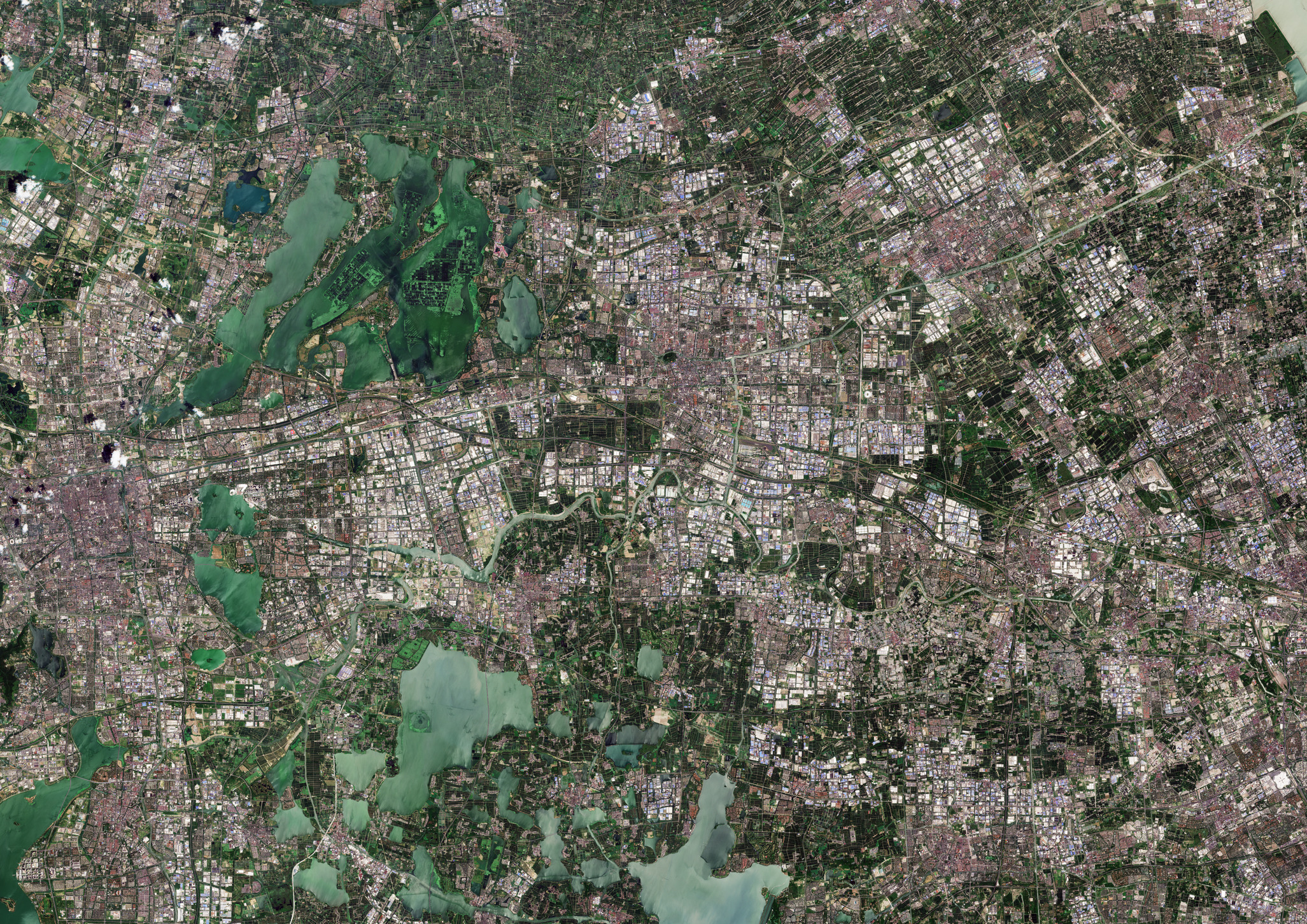
Questa immagine di Copernicus Sentinel-2 mostra l'intricata miscela di paesaggi naturali, rurali e urbani presenti intorno a Kunshan, una città nella Cina orientale.
Situata nel cuore della regione del delta del fiume Yangtze nella provincia di Jiangsu, Kunshan ospita circa 1,6 milioni di persone. Si trova tra i principali snodi di Shanghai ad est e Suzhou ad ovest.
Kunshan si estende su oltre 900 kmq di terreno prevalentemente pianeggiante. A causa della sua geografia pianeggiante la città è stata storicamente soggetta a inondazioni, una sfida resa ancora più grave dal rapido processo di urbanizzazione. In risposta Kunshan ha implementato un sistema di polder, costituito da dighe con corsi d'acqua gestiti attraverso paratoie e pompe.
Zoomando nelle aree urbane gli edifici rossi più piccoli tipicamente indicano delle case, mentre gli edifici più grandi bianchi ed azzurri sono fabbriche e magazzini.
Kunshan è anche nota per le sue antiche città sull’acqua ben conservate, tra cui Zhouzhuang, la più famosa della Cina. Risalente a più di 900 anni fa, Zhouzhuang - in basso al centro dell'immagine - è nota per le sue case antiche e i pittoreschi corsi d'acqua.
La città è anche costellata da numerosi laghi, i più grandi dei quali sono visibili nell'immagine ed includono il lago Dianshan, parzialmente visibile in basso al centro, il lago Cheng alla sua sinistra e il lago Yangcheng ai margini della città in alto a sinistra.
Il lago Yangcheng è una importante risorsa di acqua dolce per l'intera provincia ed è famoso per il granchio cinese, considerato una prelibatezza. Gli stagni rettangolari per l'allevamento dei granchi sono ben visibili al centro del lago, mentre le piante acquatiche risaltano con un colore verde brillante.
Fiumi e foreste coprono più di un quarto della città. Il fiume Wusong, visibile in colore verde chiaro al centro dell'immagine, si snoda attraverso la città, mentre i fiumi più piccoli formano un motivo a griglia.
Con una superficie di circa 15 kmq il Forest Park - una zona umida ecologica ricca di varietà di piante - e il Tinglin Park - noto per la sua vetta verde lussureggiante e le acque incontaminate - offrono fughe panoramiche dal centro urbano.
Scarica immagine HiRes (13,99 MB - .JPG)
Scarica immagine HiRes (101,45 MB - .TIF)
---
Kunshan, China
This Copernicus Sentinel-2 image captures the intricate blend of natural, rural and urban landscapes around Kunshan, a city in eastern China.
Situated in the heart of the Yangtze River Delta region in Jiangsu Province, Kunshan is home to about 1.6 million people. It nestles between the major hubs of Shanghai to the east and Suzhou to the west.
Kunshan covers over 900 sq km of mostly flat terrain. Owing to its low-lying geography, the city has historically been prone to flooding, a challenge exacerbated by rapid urbanisation. In response, Kunshan has implemented a polder system consisting of dikes with waterways managed through gates and pumps.
Zooming into the urban areas, the smaller red buildings typically indicate houses, while larger white and light-blue buildings denote factories and warehouses.
Kunshan is also known for its well-preserved ancient water towns, including Zhouzhuang, the most famous in China. Dating back more than 900 years, Zhouzhuang, at the bottom centre of the image, is known for its ancient houses and scenic waterways.
The city is also dotted with numerous lakes, the largest of which visible in the image include Dianshan Lake, partially visible in the bottom centre, Cheng Lake to its left, and Yangcheng Lake at the city edge in the top left.
Yangcheng Lake is an important freshwater resource for the whole province and is famous for the Chinese mitten crab, which is considered a delicacy. The rectangular crab farming ponds are clear to see in the middle of the lake, while water plants stand out in bright green.
Rivers and forests cover more than a quarter of the city. The Wusong River, visible in light green across the centre of the image, winds through the city, while smaller rivers form a grid-like pattern.
Covering an area of around 15 sq km, Forest Park, an ecological wetland filled with a variety of plants, and Tinglin Park, known for its lush green peak and pristine waters, offer scenic escapes from the urban centre.
[Credits: contains modified Copernicus Sentinel data (2024), processed by ESA - Translation: Gianluca Pititto]
