


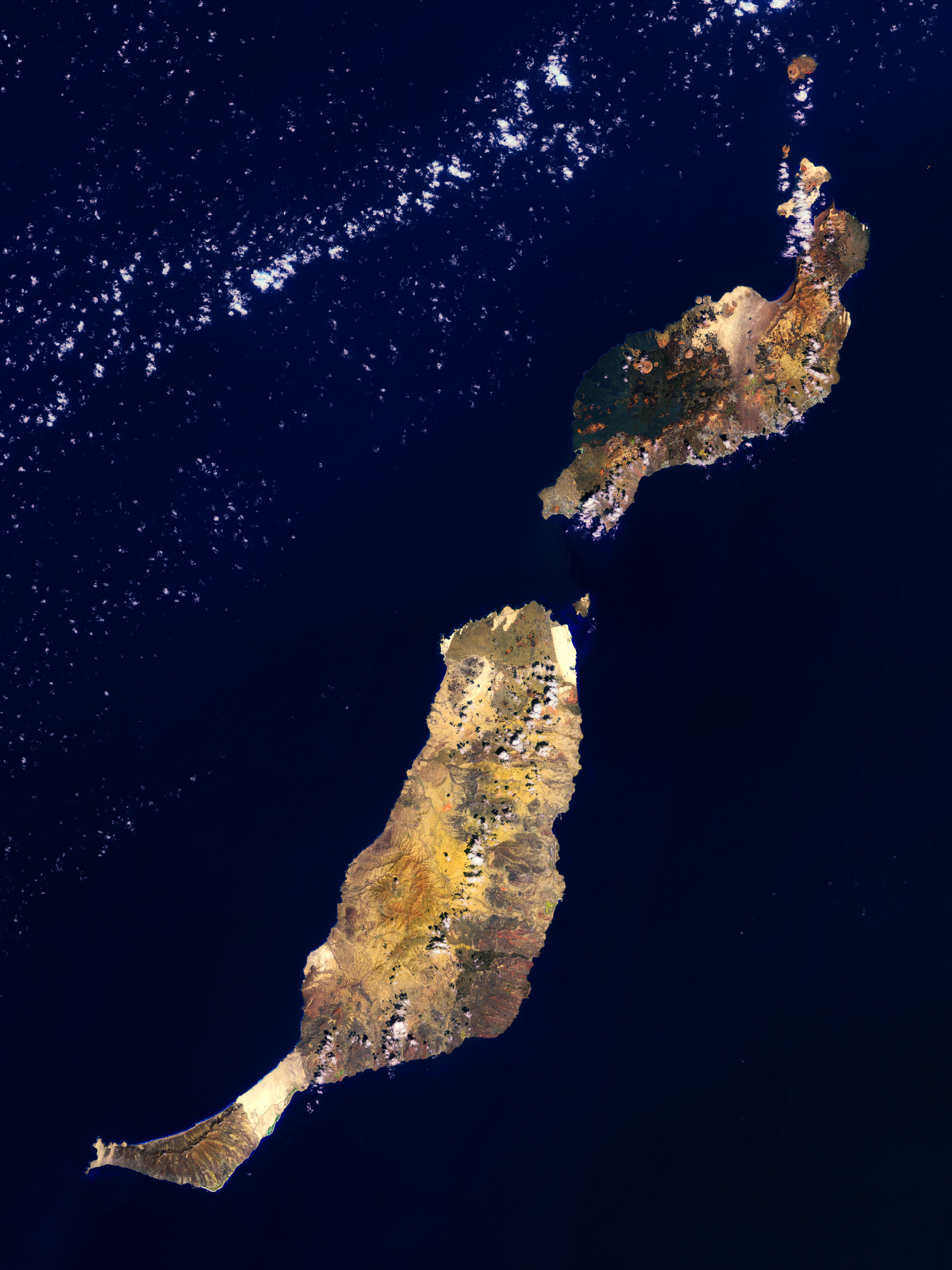
Fuerteventura e Lanzarote, che sono parte delle isole Canarie che si trovano nell’Oceano Atlantico settentrionale, sono mostrate in questa immagine a falsi colori catturata dalla missione Copernicus Sentinel-2.
Le isole Canarie sono un gruppo di isole oceaniche di natura vulcanica, formatesi milioni di anni fa per attività vulcanica. La regione spagnola e l’arcipelago si trovano a circa 100 km al largo della costa settentrionale dell’Africa ed a 1000 km dalla penisola iberica. Le otto isole principali sono (dalla più grande alla più piccola per estensione superficiale): Tenerife, Fuerteventura, Gran Canaria, Lanzarote, La Palma, La Gomera, El Hierro ed infine La Graciosa. L’arcipelago include inoltre molte isole più piccole ed isolotti.
Lanzarote, l’isola più ad est delle Canarie, è visibile in alto a destra nell’immagine. Con oltre 150 000 abitanti è l’isola più popolosa delle Canarie dopo Tenerife e Gran Canaria. Copre un’area di 845 kmq, fatto che la rende la quarta isola più grande dell’arcipelago.
Lanzarote ha una lunga storia di eruzioni e spesso è chiamata ‘isola dei 1000 vulcani’, pur essendo in realtà l’isola meno montuosa delle Canarie. Il picco più alto è il vulcano Peñas del Chache nei pressi di Haría, nella parte più a nord dell’isola, con una elevazione di 670 m sopra il livello medio del mare. Il Parco Nazionale di Timanfaya si può osservare nella parte sudovest dell’isola ed è formato interamente da terreno vulcanico.
L’isola di Fuerteventura, la seconda più grande delle Canarie, sorge a sudovest di Lanzarote, attraverso lo stretto di Bocaina. La sua area totale è di 1731 kmq e l’isola è lunga circa 110 km e larga non più di 30 km. Fuerteventura è la più vecchia isola dell’arcipelago delle Canarie, essendo comparsa tra 12 e 20 milioni di anni fa a causa soprattutto di attività vulcanica.
L’isola è piuttosto piatta e presenta un panorama desertico fatto di sabbia e rocce, ma anche di lunghe spiagge. Il centro dell’isola è costituito da una ampia e lunga valle che da nord a sud è sezionata da una serie di vulcani estinti ed erosi. La costa occidentale è punteggiata da scogliere frastagliate e da piccole baie.
A nordest di Fuerteventura si trova l’isola chiamata Isla de Lobos, separata dallo stretto El Rio, che è profondo 15 m. L’isola, che ha una superficie di soli sei kmq, ospita un vulcano estinto alto 127 m.
Questa immagine è stata catturata il 24 settembre 2021 dalla missione Copernicus Sentinel-2, una missione a due satelliti realizzata per fornire copertura e distribuzione di dati necessari al programma europeo Copernicus. L’immagine è stata processata selezionando le bande spettrali utilizzate per classificare le caratteristiche geologiche.
Scarica immagine MedRes (1,83 MB - .JPG)
Scarica immagine HighRes (271,72 MB - .TIF)
---
Fuerteventura and Lanzarote
Fuerteventura and Lanzarote, part of the Canary Islands lying in the North Atlantic Ocean, are featured in this false-colour image captured by the Copernicus Sentinel-2 mission.
The Canary Islands are a group of ocean island volcanoes that were formed by volcanic activity millions of years ago. The Spanish region and archipelago is located around 100 km off the north coast of Africa and 1000 km from the Iberian Peninsula. The eight main islands are (in order of largest to smallest in area) Tenerife, Fuerteventura, Gran Canaria, Lanzarote, La Palma, La Gomera, El Hierro and La Graciosa. The archipelago also includes many smaller islands and islets.
Lanzarote, the easternmost of the Canary Islands, is visible in the top-right of the image. With over 150 000 inhabitants, it is the third most populous Canary Island, after Tenerife and Gran Canaria. It covers an area of 845 sq km, making it the fourth-largest of the islands in the archipelago.
Lanzarote has a long history of eruptions and is often referred to as the ‘Island of the 1000 volcanoes’, yet it is actually the least mountainous Canarian Island. The highest mountain is the volcano Peñas del Chache near Haría in the northern part of the island, which is 670 m above sea level. The Timanfaya National Park can be seen in the southwest part of the island and is entirely made up of volcanic soil.
Fuerteventura Island, the second largest of the Canaries, lies southwest of Lanzarote, across the Bocaina Strait. Its total area is 1731 sq km and the island is around 110 km long and no more than 30 km wide. Fuerteventura is the oldest island in the Canary Archipelago, having risen between 12 and 20 million years ago owing largely to volcanic activity.
The island is fairly flat and has a desert landscape of sand and stones as well as long beaches. The centre of the island is made up of a wide, elongated valley and, from north to south, is dissected by a series of extinct, eroded volcanoes. The west coast is dotted with rugged cliffs and small bays.
To the northeast of Fuerteventura, separated by the 15 m deep strait El Río, lies the island of Isla de Lobos. The only six sq km island is home to a 127 m high extinct volcano.
This image was captured on 24 September 2021 by the Copernicus Sentinel-2 mission – a two-satellite mission to supply the coverage and data delivery needed for Europe’s Copernicus programme. The image was processed by selecting spectral bands that can be used for classifying geological features.
[Credits: contains modified Copernicus Sentinel data (2021), processed by ESA - Translation: Gianluca Pititto]
Copia qui lo "short link" a questo articolo
www.geoforall.it/{sh404sef_shurl}
