

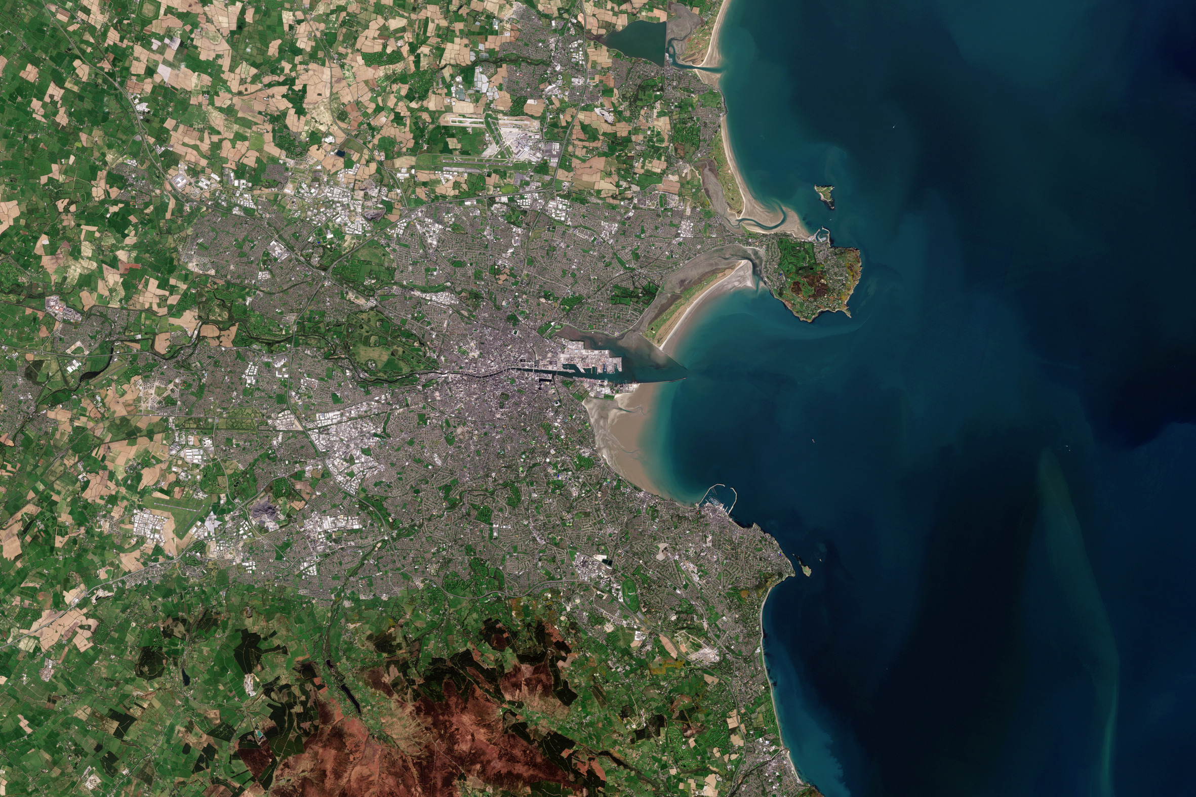
Dublino, la capitale e la città più grande dell'Irlanda, è mostrata in questa immagine di Copernicus Sentinel-2.
Dublino sorge vicino al punto mediano della costa orientale dell'Irlanda nella provincia di Leinster. La città, che copre un'area di circa 115 kmq, è delimitata a sud dalle montagne di Dublino - una bassa catena montuosa – mentre a nord e ad ovest è circondata da terreni agricoli pianeggianti.
La città si trova a cavallo del fiume Liffey, che nasce nelle montagne di Wicklow e scorre per circa 80 km verso est attraversando la città, al cui interno è canalizzato e delimitato da banchine. Il fiume sfocia poi nella baia di Dublino, un braccio del Mare d'Irlanda.
Gli edifici storici della città includono il Castello di Dublino - risalente al XIII secolo - e la Cattedrale di San Patrizio. Dublino ospita anche la Guinness Storehouse, che si sviluppa su sette piani che circondano un atrio di vetro realizzato a forma di pinta di Guinness. Il settimo piano ospita il Gravity Bar con una vista spettacolare su Dublino.
Ci sono molti spazi verdi intorno alla città, tra cui il Phoenix Park e St. Stephen's Green. Phoenix Park, visibile a circa 3 km a ovest del centro della città, presenta un muro perimetrale di 16 km che racchiude 707 ettari di spazio verde, fatto che lo rende uno dei più grandi parchi pubblici chiusi presenti nella capitali d’Europa.
La baia di Dublino è larga circa 10 km lungo il suo lato nord-sud e lunga circa sette km. North Bull Island, situata nella parte nord-ovest della baia, presenta una spiaggia sabbiosa lunga cinque km, chiamata Dollymount Strand. Bull Island fu creata 200 anni fa a seguito della costruzione del muro nord del porto di Dublino e continua a crescere verso il mare.
Gli habitat dell'isola includono spiagge, dune, distese di fango, praterie e paludi. L'isola è stata la prima riserva ufficiale di uccelli nel paese negli anni ‘30. Nel 1981, ha raggiunto lo status di Riserva della Biosfera dell'UNESCO grazie sia ai suoi habitat e specie rare minacciati d’estinzione, sia grazie alla sua utilizzazione da parte di un numero importante di uccelli svernanti.
Copernicus Sentinel-2 è una missione a due satelliti. Ogni satellite trasporta una fotocamera ad alta risoluzione che riprende la superficie terrestre in 13 bande spettrali. I dati di Copernicus Sentinel-2 vengono utilizzati per monitorare i cambiamenti nella copertura del suolo, nell'agricoltura e nelle acque costiere e interne.
Scarica immagine MedRes (01,58 MB - .JPG)
Scarica immagine HighRes (42,59 MB - .TIF)
---
Dublin, Ireland
Dublin, the capital and largest city of Ireland, is featured in this Copernicus Sentinel-2 image.
Dublin is located near the midpoint of Ireland’s east coast in the province of Leinster. The city, which covers an area of around 115 sq km, is bordered by the Dublin Mountains, a low mountain range to the south, and is surrounded by flat farmland to the north and west.
The city straddles the River Liffey, which rises in the Wicklow Mountains and flows around 80 km eastwards through the city of Dublin, in which it is canalised and bordered with quays. It then empties into Dublin Bay, an arm of the Irish Sea.
The city’s historical buildings include Dublin Castle, which dates back to the 13th Century, and St Patrick’s Cathedral. Dublin is also home to the Guinness Storehouse, which covers seven floors surrounding a glass atrium shaped in the form of a pint of Guinness. The seventh floor houses the Gravity Bar with spectacular views of Dublin.
There are many green spaces around Dublin which include Phoenix Park and St. Stephen’s Green. Phoenix Park, visible around 3 km west of the city centre, has a 16 km perimeter wall enclosing 707 hectares of green space making it one of the largest enclosed public parks in any capital city in Europe.
Dublin Bay is around 10 km wide along its north-south base and around seven km in length. North Bull Island, situated in the northwest part of the bay, features a five km long sandy beach, Dollymount Strand. Bull Island was created 200 years ago due to the construction of the north wall to Dublin Port and continues to grow seaward.
The island's habitats include beach, dunes, mud flats, grassland and marsh. The island was the first official bird sanctuary in the country in the 1930s. In 1981, it achieved status as a UNESCO Biosphere Reserve owing to its rare and threatened habitats and species along with its use by important numbers of overwintering birds.
Copernicus Sentinel-2 is a two-satellite mission. Each satellite carries a high-resolution camera that images Earth’s surface in 13 spectral bands. Data from Copernicus Sentinel-2 are used to monitor changes in land cover, agriculture, and coastal and inland waters.
[Credits: contains modified Copernicus Sentinel data (2020), processed by ESA - Translation: Gianluca Pititto]
Copia qui lo "short link" a questo articolo
www.geoforall.it/{sh404sef_shurl}
