

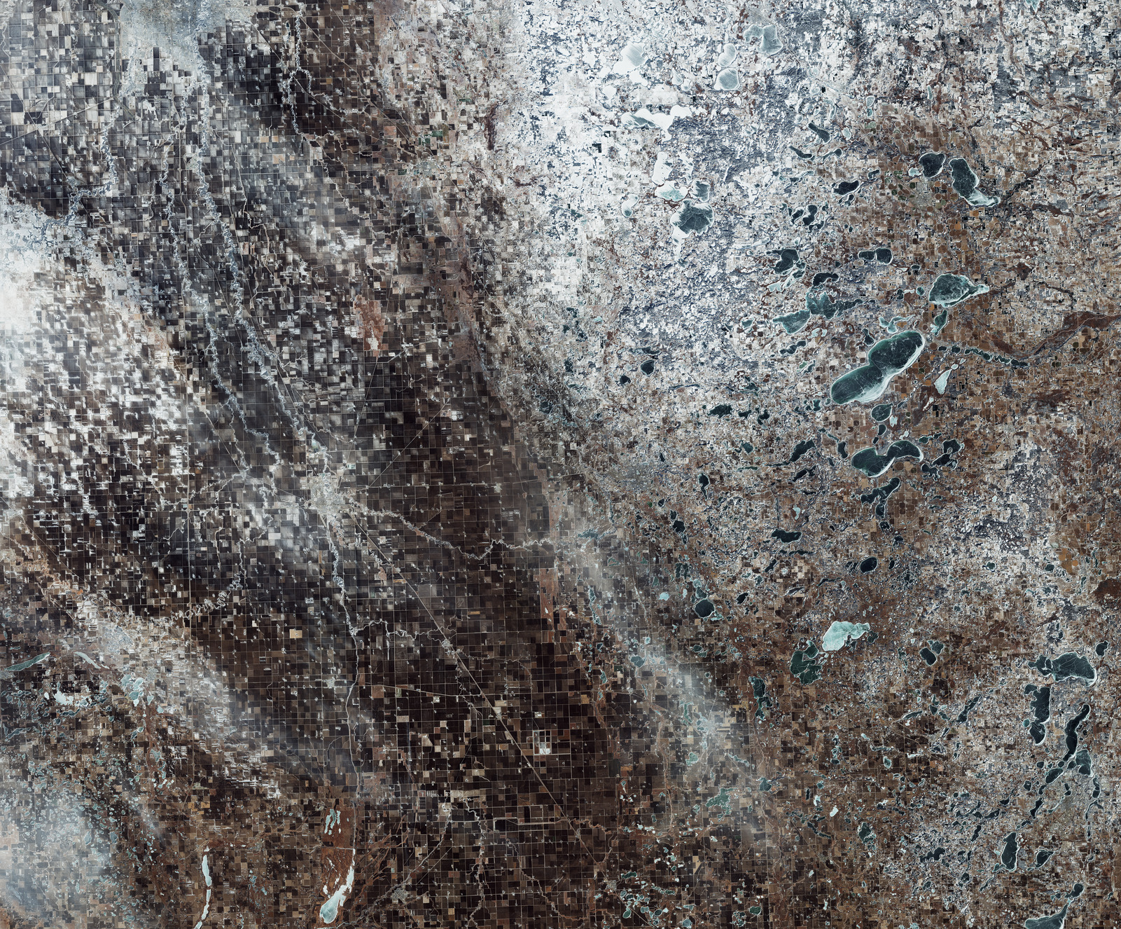
Questa immagine di Copernicus Sentinel-2 mostra i confini tra Nord e Sud Dakota con il Minnesota imbiancati da neve e da ghiaccio.
Quest’area è parte della valle del Red River, una delle più fertili valli fluviali del mondo. Essa è chiaramente visibile nell’immagine, la cui parte sinistra è dominata da una vasta estensione di terreni agricoli. I motivi geometrici dei terreni appaiono con ombreggiature marroni o bianche laddove risultano imbiancati dalla neve.
L’agricoltura - che riguarda soia, mais, grano e barbabietole da zucchero – svolge un ruolo chiave nell’economia locale.
Il tortuoso corso del Red River, formato dalla confluenza del Bois de Sioux River proveniente da sud e dall’ Otter Tail River che viene da ovest, può essere osservato di colore bianco attraverso l’immagine. Il fiume scorre per oltre 700 km verso nord, disegnando il confine tra Nord Dakota (a sinistra) e Minnesota (a destra).
Le città gemelle di Wahpeton (North Dakota) e Breckenridge (Minnesota), che appaiono di colore bianco nel punto di congiunzione dei due fiumi, sorgono sui lati opposti del Red River del nord. Wahpeton è appena 75 km a sud di Fargo, circostanza che rende questo territorio innevato familiare ai fan del film e delle serie Fargo.
Sul lato destro l’immagine mostra una mescolanza di terreni agricoli, aree umide e piccoli laghi, che appaiono completamente o parzialmente gelati. La caratteristica più evidente di questa zona è il lago Otter Tail, che occupa una superficie di circa 55 kmq.
Copernicus Sentinel-2 distribuisce immagini e dati necessari al programma ambientale europeo Copernicus. I dati sono impiegati nell'ambito di un ampio spettro di applicazioni, incluso il monitoraggio dell’impiego e dei cambiamenti del suolo, la gestione del suolo, l’agricoltura, le foreste ed i disastri naturali (inondazioni, incendi forestali, frane ed erosioni).
Scarica immagine HiRes (55,28 MB - .JPG)
Scarica immagine HiRes (444,07 MB - .TIF)
---
Frozen borders
This Copernicus Sentinel-2 image captures the borders between North and South Dakota and Minnesota blanketed with snow and ice.
This area is part of the Red River Valley, one of the most fertile river valleys in the world. This is clearly visible in the image, where the left side is dominated by a vast expanse of agricultural fields. Their geometric patterns can be seen in shades of brown, or white where they are blanketed with snow.
Agriculture, which includes soybeans, corn, wheat and sugar beets, plays a key role in the local economy.
Formed by the confluence of the Bois de Sioux River from south and the Otter Tail River from the west, the winding course of the Red River of the North can be seen in white across the image. The river flows for over 700 km northwards, marking the border between North Dakota (left) and Minnesota (right).
Visible in white where the two rivers meet, the twin cities of Wahpeton, North Dakota, and Breckenridge, Minnesota, lie on opposite sides of the Red River of the North. Wahpeton is just 75 km south of Fargo, making this snowy territory familiar to fans of the Fargo film and series.
On the right, the image features a blend of agricultural fields, wetlands and small lakes, that appear to be fully or partially frozen. The largest feature here is the Otter Tail Lake, covering about 55 sq km.
Copernicus Sentinel-2 delivers imagery and data needed for Europe’s environmental Copernicus programme. Data are used for a wide range of applications, including monitoring land use and changes, land management, agriculture, forestry and natural disasters (floods, forest fires, landslides and erosion).
[Credits: contains modified Copernicus Sentinel data (2025), processed by ESA - Translation: Gianluca Pititto]
