

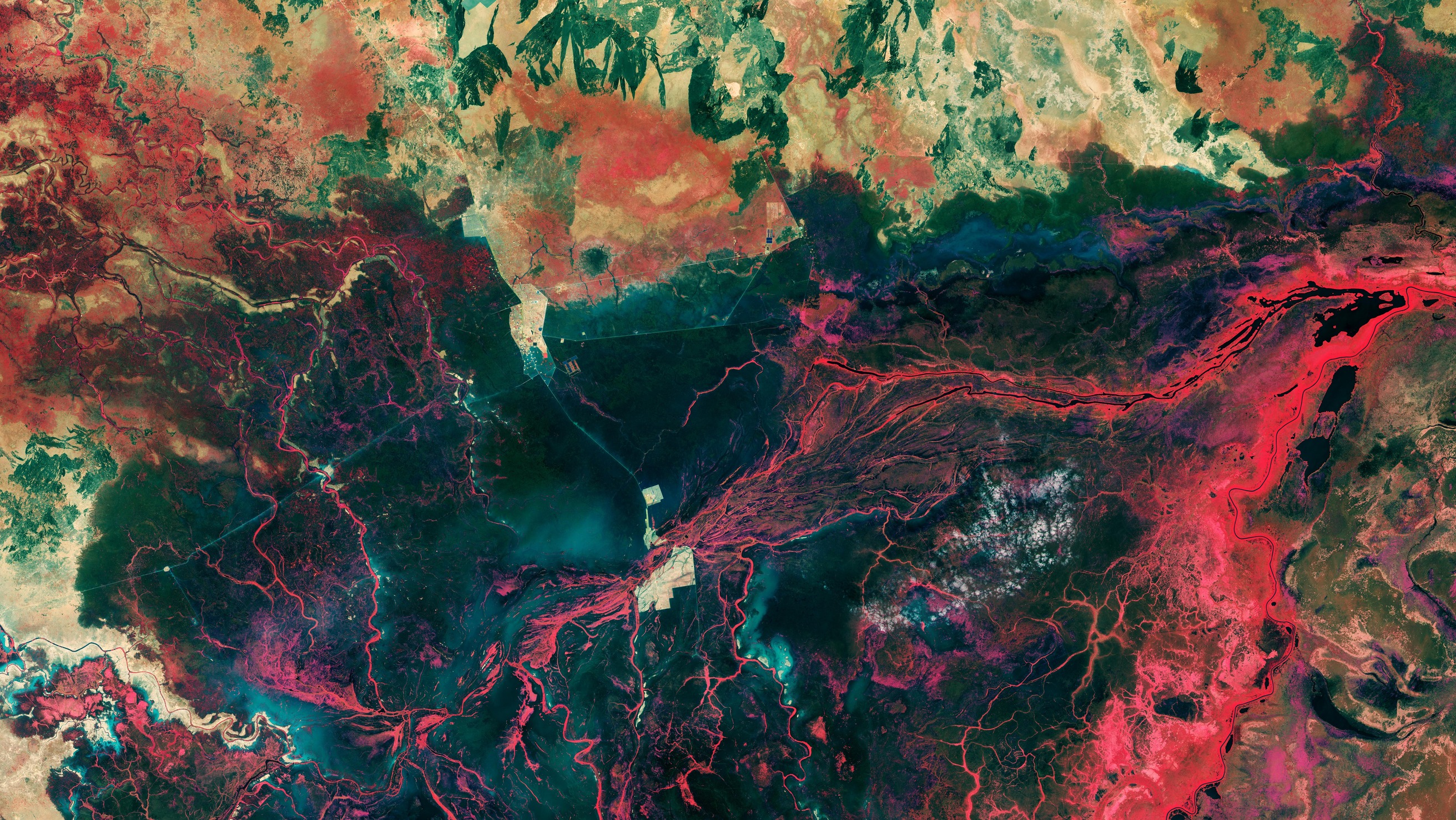
Il paesaggio intorno alla città di Bentiu, in Sud Sudan, è mostrato in questa immagine di Copernicus Sentinel-2
La maggior parte della popolazione del Sud Sudan vive in zone rurali e dipende dall'agricoltura, dalla pesca e dalla pastorizia, per il cibo ed il reddito. Il paese ha sempre sperimentato un certo grado di inondazioni stagionali, che normalmente si ritirano nella stagione secca. Tuttavia, quattro anni consecutivi di incessanti inondazioni hanno sommerso villaggi, terreni agricoli e strade. Nel 2023, la profondità delle acque alluvionali in alcuni punti ha raggiunto i 190 cm.
Questa immagine a falsi colori, catturata nel gennaio 2023, mostra chiaramente l'estensione delle aree allagate intorno a Bentiu. Le informazioni ottenuto con il canale del vicino infrarosso della missione sono state utilizzate per elaborare questa immagine in modo che i corpi idrici appaiano in blu scuro o nero. I sedimenti nelle acque sono invece di colore blu brillante, mentre le vivaci sfumature di rosso, principalmente lungo i bordi dei fiumi, segnalano presenza di vegetazione.
L'area giallastra al centro dell'immagine è la città di Bentiu. Si staglia come un'isola circondata da inondazioni. Bentiu si trova sulla riva meridionale del fiume Bahr el-Ghazal, che separa la città dalla città di Rubkona sulla riva opposta. Ingrandendo, il ponte di El Salaam può essere visto a cavallo del fiume e collega le due città. La struttura quadrata appena a nord di Rubkona è il campo sfollati di Bentiu IDP, dove molte persone hanno trovato rifugio dopo aver perso le loro case nelle inondazioni.
Queste terre aride ed alcune strade, visibili come linee rette di colore verde chiaro, ora si trovano sotto il livello delle acque, circondate da dighe che sono state costruite per proteggerle dalle inondazioni.
Da Bentiu il fiume Bahr el-Ghazal si snoda attraverso la pianura alluvionale inondata in direzione nord-est. La traccia appare in nero, a destra dell'immagine, mentre scorre attraverso il lago No nel Nilo Bianco.
Alimentata dal Nilo Bianco, la grande area paludosa che si estende dal centro dell'immagine verso destra in basso è il Sudd. Si tratta di una rete di canali, laghi e paludi ed è una delle più grandi pianure alluvionali dell'Africa: fornisce abbeveraggio ed alimentazione per molti mammiferi e uccelli radicati nell’area, ma anche per grandi popolazioni di specie migratorie.
Scarica immagine MedRes (6,64 MB - .JPG)
Scarica immagine HighRes (361,65 GB - .TIF)
---
Bentiu, South Sudan
The landscape around the city of Bentiu in South Sudan is featured in this Copernicus Sentinel-2 image.
The majority of the people in South Sudan live in rural areas and rely on farming, fishing or herding for food and income. The country has always experienced a degree of seasonal flooding, which normally recedes in the dry season. However, four consecutive years of incessant flooding have submerged villages, farmlands and roads. In 2023, flood waters have been deep as 190 cm in some places.
This false-colour image, captured in January 2023, clearly shows the extent of the flooded areas around Bentiu. Information from the mission’s near-infrared channel was used to process this image so water bodies appear in dark blue or black. Sediment in the waters is bright blue, while the vibrant shades of red, mainly bordering rivers, denote vegetation.
The yellowish area in the centre of the image is the city of Bentiu. It stands out like an island surrounded by floods. Bentiu lies on the southern bank of the Bahr el-Ghazal River, which separates the city from the town of Rubkona on the opposite bank. Zooming in, the El Salaam Bridge can be seen spanning the river and connecting the two cities. The square structure just north of Rubkona is the Bentiu IDP refugee camp, where many people found shelter after losing their homes in the floods.
These dry lands and some roads, visible as light green straight lines, now lie below the waterline, hemmed in by dikes that have been built to protect them from inundation.
From Bentiu, the Bahr el-Ghazal River meanders through the inundated floodplain in a northeasterly direction. It can be traced in black in the right of the image flowing through Lake No into the White Nile.
Fed by the White Nile, the large, swampy area running from the centre of the image to the bottom right is the Sudd. It is a network of channels, lakes and swamps and one of Africa’s largest floodplains, providing watering and feeding grounds for many endemic mammals and birds, as well as for large populations of migratory species.
[Credits: Credits: contains modified Copernicus Sentinel data (2023), processed by ESA - Translation: Gianluca Pititto]
