

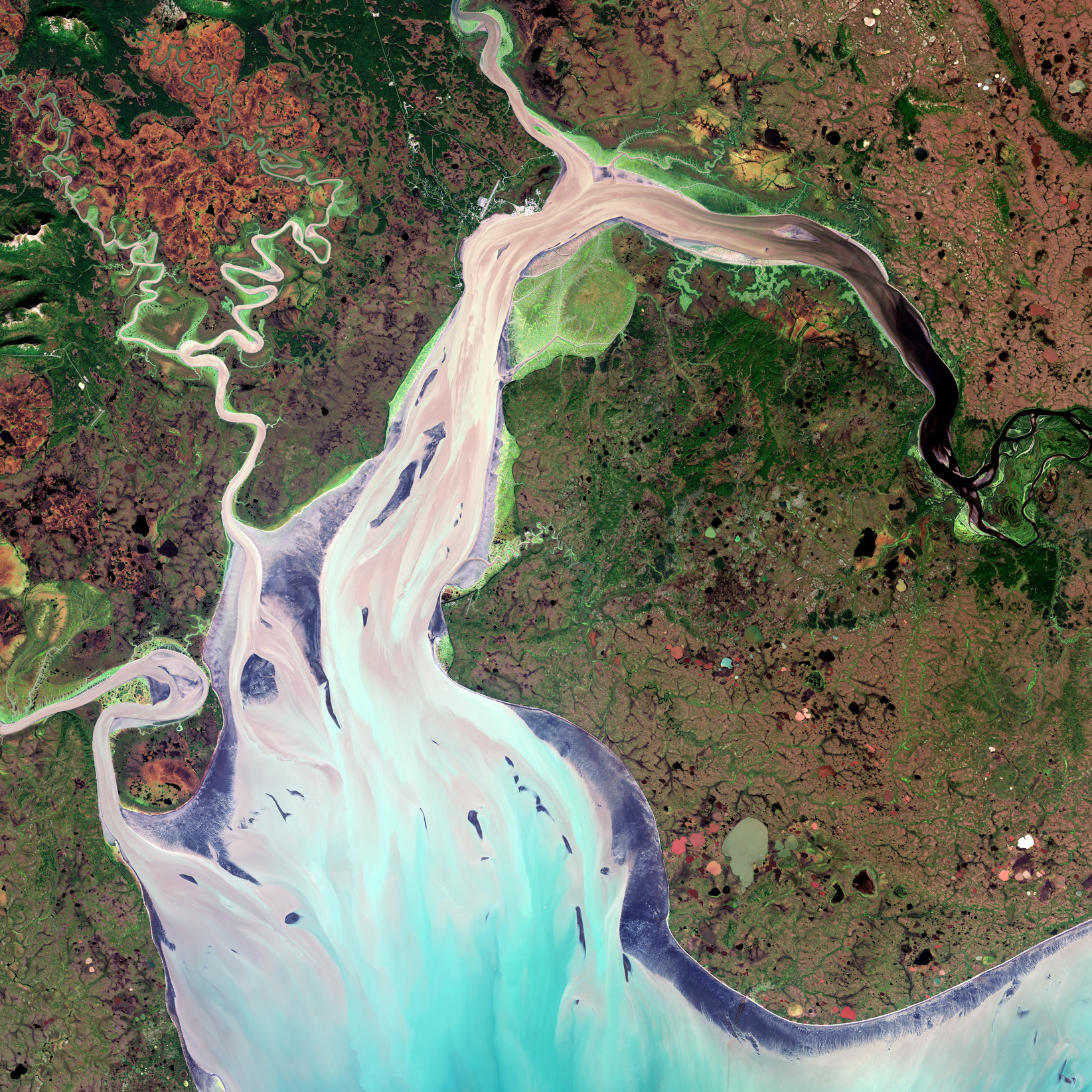
Il panorama complesso e variegato che circonda la baia di Nushagak in Alaska è mostrato in questa immagine a colori veri catturata dalla missione Copernicus Sentinel-2.
La baia di Nushagak è costituita da un ampio estuario che copre oltre 100 kmq nel sud-ovest dell’Alaska (Stati Uniti). La baia si estende principalmente da nord a sud a partire dalla foce del fiume Nushagak, prima dello sbocco nella baia di Nushagak - insenatura della baia di Bristol 50 circa a sud.
La baia è alimentata principalmente dal fiume Nushagak (visibile in alto a destra), che ha origine nella catena montuosa dell’Alaska, per poi scorrere verso sud-ovest per circa 450 km. La baia è inoltre alimentata da diversi corsi d’acqua addizionali, tra cui i fiumi Wood, Igushik, Snake e Weary.
Questa immagine in colori veri è stata catturata dalla missione Copernicus Sentinel-2. I colori scuri del fiume Nushagak sono dovuti molto probabilmente a tannino o lignina (sostanze chimiche presenti nelle piante). Tannino e lignina provenienti da radici, foglie, semi, corteccia e terreno possono filtrare nell’acqua ed essere responsabili di una colorazione marrone ed a volte anche nera. I sedimenti fluiscono quindi verso sud dove si mescolano con le acque più azzurre della baia.
La città di maggiore estensione nell’area è Dillingham, dove risiedono circa 2000 persone ed è circondata da foreste, arbusti, praterie e muschi. I fiumi, come pure le pianure attorno alla baia di Nushagak, sono ricchi di alberi a foglie caduche. Le aree di colore viola scuro lungo la baia sono costituite da fango intertidale e distese di sabbia. Se si effettua uno zoom nell’immagine si può notare che è visibile un'orlo bianco attorno alle zone meridionali della baia. Punteggiati attorno all’immagine si possono anche scorgere diversi stagni da disgelo.
La baia di Nushagak è una importante zona di transito e di sosta per decine di specie migratorie di uccelli costieri e acquatici. Inoltre, è sede di una delle attività di pesca del salmone rosso più grande ed incontaminato al mondo.
Sentinel-2 trasporta un sensore ad immagini multispettrale con una impronta al suolo di 290 km. Oltre a fornire informazioni dettagliate sulla vegetazione della Terra, Sentinel-2 è stato progettato per giocare un ruolo importante nella mappatura delle differenze nella copertura del suolo con l'obiettivo di comprendere il paesaggio, mappare il suo utilizzo e monitorare i suoi cambiamenti nel tempo.
Scarica immagine MedRes (33,03 MB - .JPG)
Scarica immagine HighRes (95,10 MB - .TIF)
---
Nushagak Bay, Alaska
The complex and diverse landscape that surrounds Nushagak Bay in Alaska is featured in this true-colour image captured by the Copernicus Sentinel-2 mission.
Nushagak Bay is a large estuary covering over 100 sq km in southwest Alaska, US. The bay runs primarily north to south from the mouth of the Nushagak River before exiting into Nushagak Bay – an inlet of Bristol Bay some 50 km southwards.
The bay is primarily fed by the Nushagak River (visible in the top right), which begins in the Alaska Range and flows southwest approximately 450 km. The bay is also fed by several additional rivers including the Wood, Igushik, Snake and Weary rivers.
This true-colour image was captured by the Copernicus Sentinel-2 mission. The dark colours of the Nushagak River are most likely due to tannins or lignins (chemical substances found in plants). Tannins and lignins from roots, leaves, seeds, bark and soil can leach into the water and give it a brown or even black colour. The sediments then flow southwards where it is mixed with the bluer waters of the bay.
The largest city in the area is Dillingham, home to around 2000 people, and is surrounded by forests, shrublands, grasslands and mosses. The rivers, as well as the lowlands around Nushagak Bay, are rich with deciduous trees. The dark purple areas along the bay are intertidal mud and sand flats. If you zoom in to the image, a white rim around the southern parts of the bay is visible. Several thaw ponds can also be seen dotted around the image.
Nushagak Bay is an important staging and stopover site for dozens of migratory shorebird and waterfowl species, and it contains one of the largest and most pristine sockeye salmon fisheries in the world.
Sentinel-2 carries a multispectral imager with a swath of 290 km. As well as providing detailed information about Earth’s vegetation, Sentinel-2 is designed to play a key role in mapping differences in land cover to understand the landscape, map how it is used and monitor changes over time.
[Credits: contains modified Copernicus Sentinel data (2020), processed by ESA - Translation: Gianluca Pititto]
Copia qui lo "short link" a questo articolo
www.geoforall.it/{sh404sef_shurl}
