

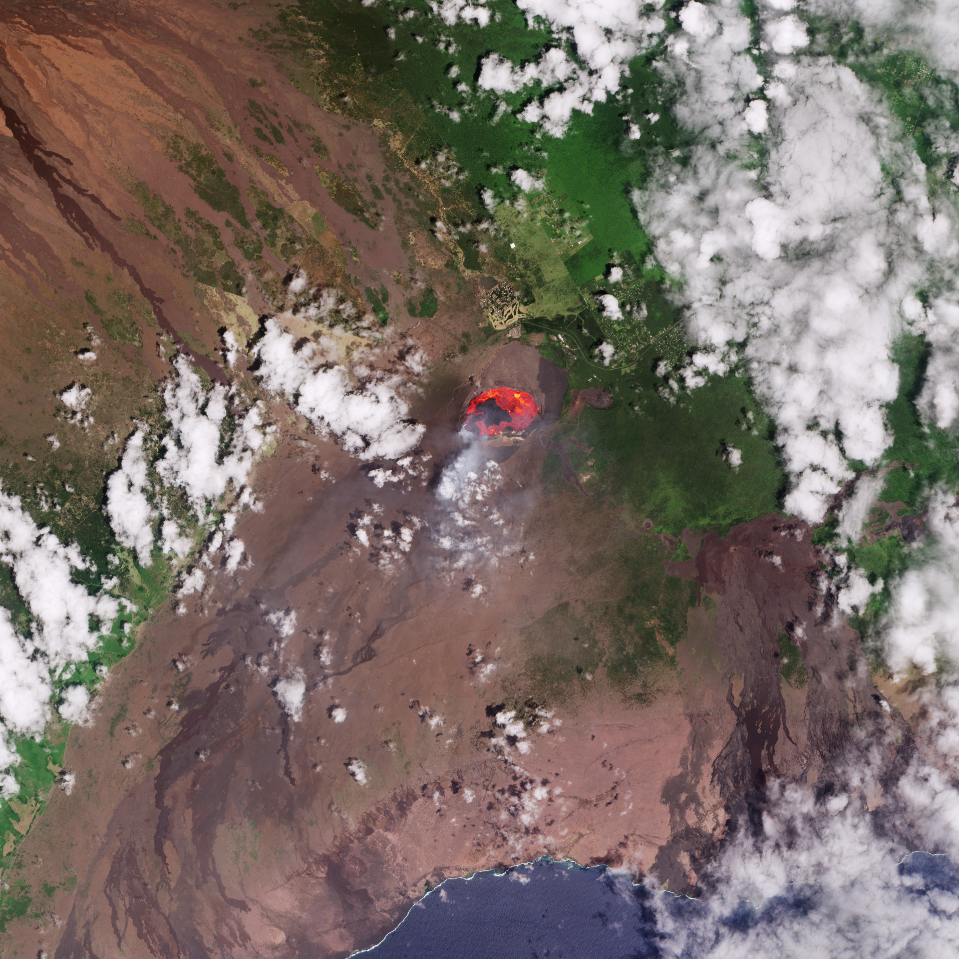
Questa immagine di Copernicus Sentinel-2 mostra un lago di lava attivo nel vulcano Kilauea che sorge sulla Big Island delle Hawaii.
Situata nell'Oceano Pacifico centrale, Big Island è l'isola più a sud-est dello stato americano delle Hawaii e, come suggerisce il nome, è la più grande isola dell'arcipelago. Essendosi formate sopra un hotspot di magma nella placca del Pacifico, le Hawaii ospitano alcuni dei più grandi vulcani attivi del mondo. Uno di questi è Kilauea, sul lato sud-orientale di Big Island.
Questa immagine di Copernicus Sentinel-2, acquisita il 3 settembre 2025, mostra un lago di lava lungo circa 2,5 km all'interno del cratere principale del Kilauea. A seguito di un episodio eruttivo del 2 settembre le fontane di lava hanno raggiunto un'altezza di circa 100 m e la lava è fluita da più bocche nel cratere principale.
Sebbene l'immagine sia stata elaborata in colori naturali, anche i canali infrarossi a onde corte della missione - che rilevano le fonti di calore - sono stati utilizzati per evidenziare la lava infuocata che scorre dal cratere, nelle tonalità arancione e rosso. Si possono anche vedere pennacchi di fumo che fuoriescono dal cratere.
L'attuale fase eruttiva è iniziata il 23 dicembre 2024 ed è proseguita fino al 2025 con ripetuti episodi di lava che si è riversata nell'aria ed è scesa dal vulcano. Segni di eruzioni più antiche sono visibili sui fianchi meridionali del cratere sotto forma di flussi verso la costa di lava solidificata di colore marrone scuro.
A differenza dell'evento qui raffigurato, che è stato confinato all'interno del cratere sommitale e ha rappresentato una piccola minaccia per le comunità vicine, l' eruzione iniziata nel maggio 2018 è stata una delle più distruttive nella storia registrata del Kilauea. Ha distrutto più di 600 case e prodotto circa 320.000 piscine olimpioniche di lava che hanno rimodellato il paesaggio.
Come vediamo nell'immagine, la roccia vulcanica crea un terreno accidentato, che contrasta con la vegetazione lussureggiante ed i campi circostanti. In particolare, le aree verde chiaro e gialle a nord del cratere principale corrispondono ad insediamenti umani, strade e piantagioni.
Big Island, come le altre isole hawaiane, possiede foreste tropicali dovute alla combinazione di fertile terreno vulcanico e forti piogge. Le nuvole visibili in tutta l'immagine si formano quando gli alisei del Pacifico soffiano attraverso le montagne in mezzo all'oceano.
Le missioni satellitari come Copernicus Sentinel-2 sono un modo eccellente per monitorare le eruzioni vulcaniche, in quanto possono visualizzare pennacchi di fumo, colate laviche, colate di fango e fessure del terreno e possono essere utilizzate per aiutare nella valutazione dei danni.
Scarica immagine HiRes (1,22 MB - .JPG)
Scarica immagine HiRes (20,13 MB - .TIF)
---
Kilauea lava lake, Hawaii
This Copernicus Sentinel-2 image captures an active lava lake on the Kilauea volcano on Hawaii’s Big Island.
Located in the central Pacific Ocean, Big Island is the southeastern-most island in the US state of Hawaii and, as its name suggests, the largest in the archipelago. Having formed above a magma hotspot in the Pacific plate, Hawaii has some of the world’s largest active volcanoes. One of these is Kilauea on the southeastern side of Big Island.
This Copernicus Sentinel-2 image from 3 September 2025 shows a lava lake approximately 2.5 km in length, inside the main crater of Kilauea. Following an eruptive episode on 2 September, lava fountains reached about 100 m high and lava flowed from multiple vents in the main crater.
Although the image has been processed in natural colour, the mission’s shortwave infrared channels, which detect heat sources, were also used to highlight the fiery lava flowing from the crater in orange and red. Plumes of smoke can also be seen leaking from the crater.
The current eruptive phase began on 23 December 2024 and continued into 2025 with repeated episodes of lava spewing into the air and flowing down the volcano. Signs of older eruptions are visible on the southern flanks of the crater as dark brown flows of solidified lava towards the coast.
Unlike the event pictured here, which was confined within the summit’s crater and posed little threat to the nearby communities, the eruption that began in May 2018 was one of the most destructive in Kilauea’s recorded history. It destroyed more than 600 homes and produced about 320 000 Olympic-sized swimming pools’ worth of lava that reshaped the landscape.
As we see in the image, the volcanic rock creates a rugged terrain which contrasts with the surrounding lush vegetation and fields. In particular, light green and yellow areas north of the main crater correspond to human settlements, roads and plantations.
Big Island, like the other Hawaiian islands, has tropical forests from the combination of fertile volcanic soil and heavy rainfall. The clouds visible throughout the image form when the Pacific trade winds blow across the mountains in the middle of the ocean.
Satellite missions such as Copernicus Sentinel-2 are an excellent way to monitor volcanic eruptions, as they can image smoke plumes, lava flows, mudslides and ground fissures and can be used to help assess damage.
[Credits: contains modified Copernicus Sentinel data (2025), processed by ESA - Translation: Gianluca Pititto]
