

With the release of the Leica TS20, Leica Geosystems ventures beyond incremental updates, offering a total robotic station rebuilt from the ground up. The TS20 introduces embedded edge AI, robust environmental protection, and next-gen connectivity—raising the bar for what a surveying instrument can be. This review revisits the fundamentals of robotic total stations, evaluates the TS20’s innovations, and explores its possible applications, while candidly addressing the open questions that remain.
Reinventing a Classic, with a Modern Twist
The core function of a total station remains unchanged: measuring angles and distances to generate precise spatial coordinates. Yet the evolution from mechanical theodolites to today’s fully robotic RTS systems—capable of single-operator control and automated target tracking—has revolutionized field workflows. Despite this, many current RTS models still fall short under real-world conditions, with issues like ambiguous prism configurations, signal occlusions, harsh weather, and unreliable connectivity.
Enter the TS20. Leica’s newest flagship isn’t just upgraded—it’s reimagined. Featuring a built-in neural processing unit (NPU), this instrument doesn’t simply measure; it interprets. Designed as an intelligent field node, the TS20 could redefine the future of autonomous surveying.
What’s New—And Why It Matters
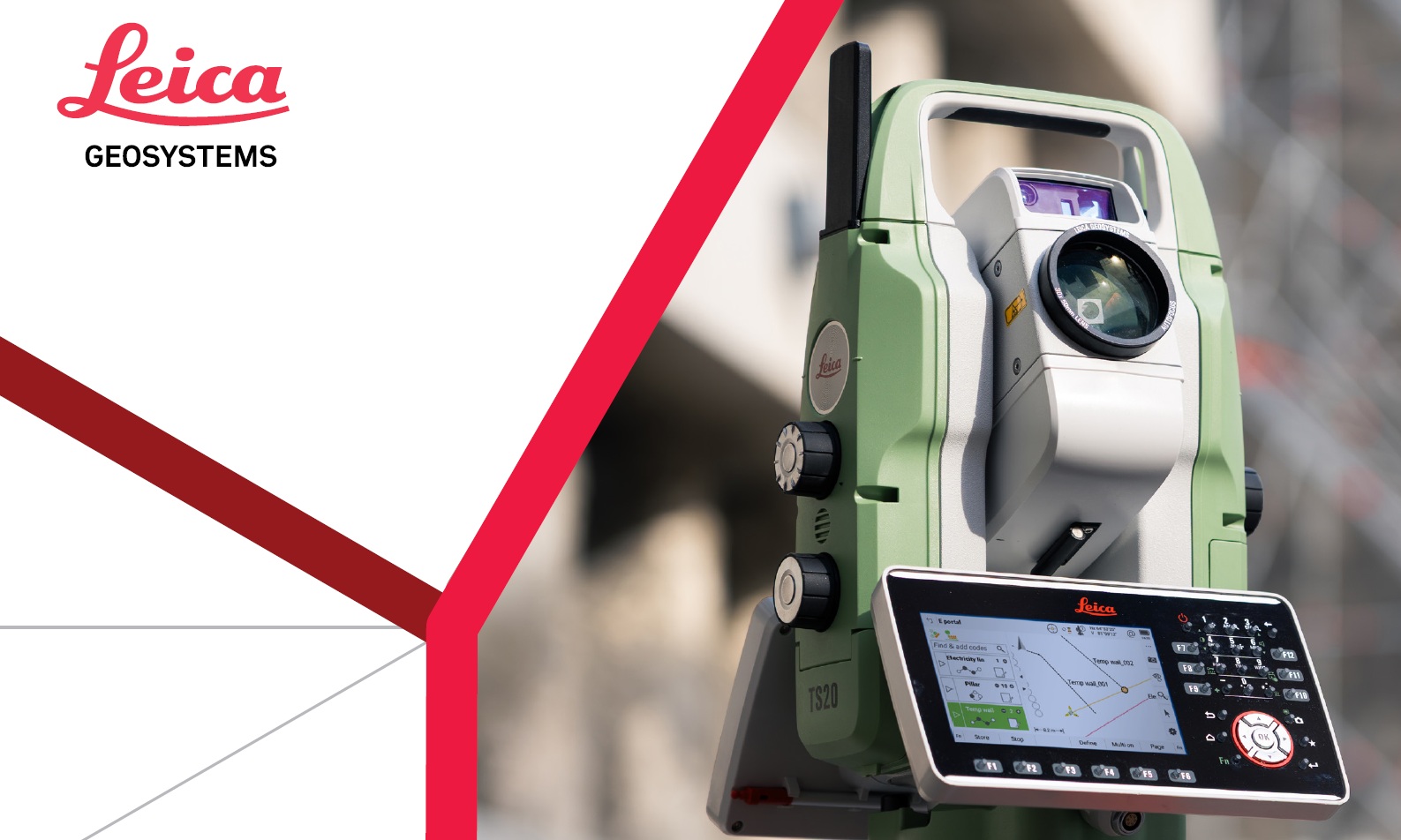
At the heart of the TS20 lies its edge AI architecture, processing visual and spatial data directly on-device. This empowers the system to recognize targets, detect mismatches, and maintain tracking—all without relying on cloud computing. Features like AI-Detect classify prism types in real time, warning the operator of anomalies, while Automatic Target Recognition (ATR) performs well in low-visibility environments. A forthcoming firmware update promises AI-Follow, designed to keep the AutoPole in view even as it momentarily disappears behind people or vegetation.
This leap in automation isn’t without caveats. AI models require extensive training, and their reliability under non-standard conditions—like unusual reflectors or erratic lighting—remains untested in publicly available trials. On the mechanical side, the TS20 is built for resilience. Its IP66 rating protects against dust and high-pressure water jets, and its faster, maintenance-free drive motors may reduce both downtime and long-term operating costs.
Performance-wise, the updated EDM module allows for higher sampling rates, while improved processing speeds enable quicker boot-up, calculations, and data logging—paving the way for real-time or near-real-time surveying. Connectivity gets a major upgrade too. With mobile internet, long-range Bluetooth, and Wi-Fi, the TS20 transforms from a stand-alone instrument into a smart, IoT-enabled sensor. Security features like GeoCloud Protect enable geo-fencing and remote locking—valuable in remote or theft-prone deployments.
Equally important, the TS20 integrates seamlessly with Leica’s ecosystem, including the AutoPole AP20, Captivate software, and GEOMOS monitoring suite. This compatibility is a strategic advantage for existing Leica users.
Promising Use Cases—And Critical Unknowns
The TS20 appears built for high-demand applications: structural health monitoring, geotechnical slope analysis, and UAV or robotics-assisted mapping. Infrastructure like bridges, dams, or towers—any structure affected by vibration or long-term displacement—could benefit from its high sampling rate and quick reacquisition. In such scenarios, the TS20 could detect sub-millimeter shifts or confirm as-built conditions under live loads.
In hazard-prone or remote areas, where traditional instruments may degrade or require regular upkeep, the TS20’s rugged design and automation offer real operational value. As part of a multi-sensor network, it could provide geodetic ground-truth for drones, mobile mapping platforms, or autonomous ground robots.
However, the very feature that sets the TS20 apart—its embedded AI—also raises key concerns. Will its prism recognition algorithms hold up in cluttered or dynamic environments? Can AI-Follow maintain lock through dense vegetation or moving crowds? And how will the device perform in terms of battery life and heat management during long sessions in extreme conditions?
Complexity and cost are other potential hurdles. For simpler tasks or smaller firms, traditional RTS units might still offer a better return on investment. There’s also the issue of long-term software support: the need for regular firmware updates and assurance of backward compatibility may influence the TS20’s practical lifespan more than its hardware specs.
Where Science Comes In: A Call for Empirical Validation
Despite its impressive feature set, one thing is missing: independent field validation. Currently, there are no peer-reviewed benchmarks, published case studies, or direct comparisons with previous RTS models—making the TS20 a prime candidate for academic and professional scrutiny.
A robust validation plan could include:
- Controlled lab comparisons testing detection accuracy, reacquisition time, angular precision, and environmental robustness
- Simulated dynamic displacements, evaluating latency and noise during oscillation patterns
- Long-term field deployments in real geotechnical contexts, assessing drift and reliability over time
- Multi-instrument configurations to test 6DOF pose reconstruction across brands
- Security and IoT trials to assess GeoCloud Protect under false-positive scenarios and connectivity failures
Such studies could provide immense value to the geospatial community—clarifying the TS20’s capabilities, surfacing its limitations, and unlocking new workflows in data fusion, real-time monitoring, and autonomous operations.
Final Thoughts
The Leica TS20 isn’t just another robotic total station—it’s a statement of intent. With embedded edge AI, rugged construction, high-speed data handling, and integrated connectivity, it points toward a future where measurement is no longer passive, but intelligent and adaptive.
Still, its real-world impact won’t be defined by specs, but by how it performs under pressure. As it stands, the TS20 is promising—but unproven. The geospatial community should watch closely—and more importantly, put it to the test.
